You are here: Home > Network List > IU - Global Seismograph Network (GSN - IRIS/USGS) Stations List
> Station RSSD Black Hills, South Dakota, USA > Earthquake Result Viewer
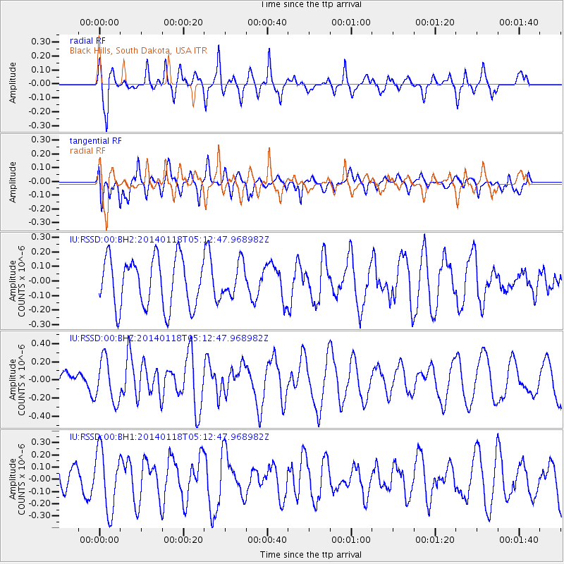
RSSD Black Hills, South Dakota, USA - Earthquake Result Viewer
*The percent match for this event was below the threshold and hence no stack was calculated.
| Earthquake location: |
Bonin Islands, Japan Region |
| Earthquake latitude/longitude: |
28.9/142.3 |
| Earthquake time(UTC): |
2014/01/18 (018) 05:00:43 GMT |
| Earthquake Depth: |
18 km |
| Earthquake Magnitude: |
5.5 MW |
| Earthquake Catalog/Contributor: |
ISC/ISC |
|
| Network: |
IU Global Seismograph Network (GSN - IRIS/USGS) |
| Station: |
RSSD Black Hills, South Dakota, USA |
| Lat/Lon: |
44.12 N/104.04 W |
| Elevation: |
2090 m |
|
| Distance: |
85.4 deg |
| Az: |
41.447 deg |
| Baz: |
306.336 deg |
| Ray Param: |
$rayparam |
*The percent match for this event was below the threshold and hence was not used in the summary stack. |
|
| Radial Match: |
57.4246 % |
| Radial Bump: |
380 |
| Transverse Match: |
43.87078 % |
| Transverse Bump: |
400 |
| SOD ConfigId: |
3390531 |
| Insert Time: |
2019-04-10 00:52:38.439 +0000 |
| GWidth: |
2.5 |
| Max Bumps: |
400 |
| Tol: |
0.001 |
|
Signal To Noise
| Channel | StoN | STA | LTA |
| IU:RSSD:00:BHZ:20140118T05:12:47.968982Z | 1.8295118 | 2.4101493E-7 | 1.3173731E-7 |
| IU:RSSD:00:BH1:20140118T05:12:47.968982Z | 3.9807444 | 2.559907E-7 | 6.4307244E-8 |
| IU:RSSD:00:BH2:20140118T05:12:47.968982Z | 0.665354 | 1.123505E-7 | 1.6885824E-7 |
| Arrivals |
| Ps | |
| PpPs | |
| PsPs/PpSs | |


