You are here: Home > Network List > KN - Kyrgyz Seismic Telemetry Network Stations List
> Station TKM2 - > Earthquake Result Viewer
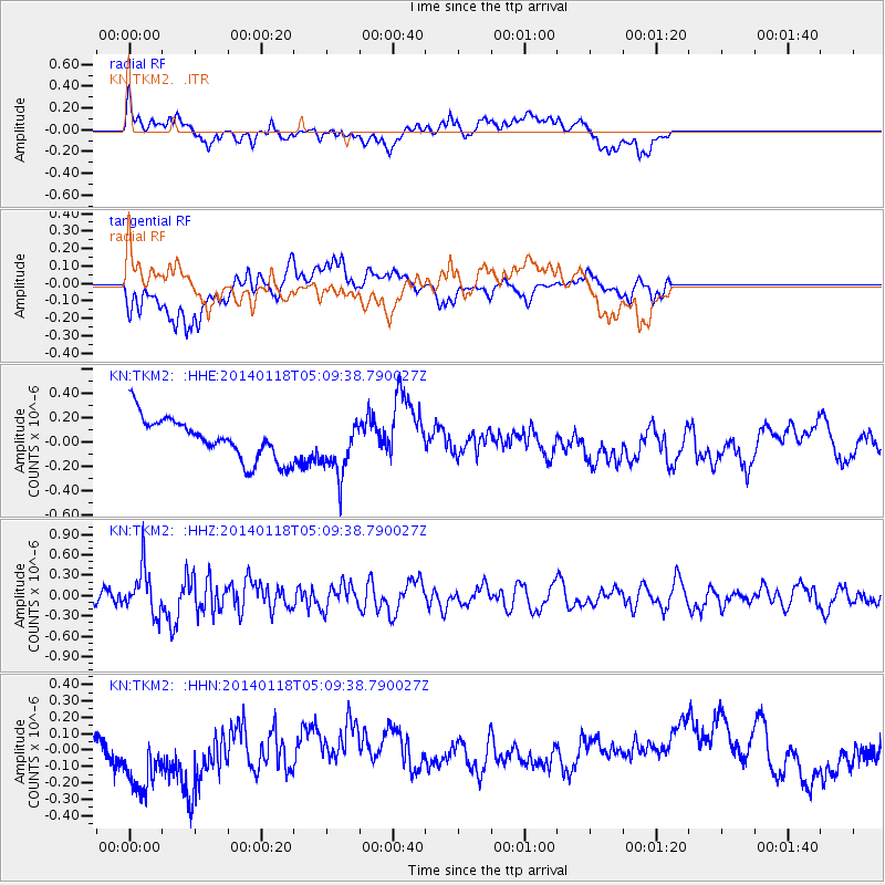
TKM2 - - Earthquake Result Viewer
*The percent match for this event was below the threshold and hence no stack was calculated.
| Earthquake location: |
Bonin Islands, Japan Region |
| Earthquake latitude/longitude: |
28.9/142.3 |
| Earthquake time(UTC): |
2014/01/18 (018) 05:00:43 GMT |
| Earthquake Depth: |
18 km |
| Earthquake Magnitude: |
5.5 MW |
| Earthquake Catalog/Contributor: |
ISC/ISC |
|
| Network: |
KN Kyrgyz Seismic Telemetry Network |
| Station: |
TKM2 - |
| Lat/Lon: |
42.92 N/75.60 E |
| Elevation: |
2020 m |
|
| Distance: |
54.5 deg |
| Az: |
303.99 deg |
| Baz: |
81.615 deg |
| Ray Param: |
$rayparam |
*The percent match for this event was below the threshold and hence was not used in the summary stack. |
|
| Radial Match: |
46.03261 % |
| Radial Bump: |
400 |
| Transverse Match: |
35.398712 % |
| Transverse Bump: |
400 |
| SOD ConfigId: |
3390531 |
| Insert Time: |
2019-04-10 00:52:46.351 +0000 |
| GWidth: |
2.5 |
| Max Bumps: |
400 |
| Tol: |
0.001 |
|
Signal To Noise
| Channel | StoN | STA | LTA |
| KN:TKM2: :HHZ:20140118T05:09:38.790027Z | 3.4767342 | 3.3575037E-7 | 9.6570616E-8 |
| KN:TKM2: :HHN:20140118T05:09:38.790027Z | 2.7217166 | 2.6313333E-7 | 9.667918E-8 |
| KN:TKM2: :HHE:20140118T05:09:38.790027Z | 1.322928 | 2.2536209E-7 | 1.7035099E-7 |
| Arrivals |
| Ps | |
| PpPs | |
| PsPs/PpSs | |


