You are here: Home > Network List > US - United States National Seismic Network Stations List
> Station WRAK Wrangell Island, Southeastern Alaska, Alaska, USA > Earthquake Result Viewer
WRAK Wrangell Island, Southeastern Alaska, Alaska, USA - Earthquake Result Viewer
| Earthquake location: |
Loyalty Islands |
| Earthquake latitude/longitude: |
-20.6/168.5 |
| Earthquake time(UTC): |
2011/01/13 (013) 16:16:41 GMT |
| Earthquake Depth: |
9.0 km |
| Earthquake Magnitude: |
6.6 MB, 7.1 MS, 7.0 MW, 6.9 MW |
| Earthquake Catalog/Contributor: |
WHDF/NEIC |
|
| Network: |
US United States National Seismic Network |
| Station: |
WRAK Wrangell Island, Southeastern Alaska, Alaska, USA |
| Lat/Lon: |
56.42 N/132.35 W |
| Elevation: |
81 m |
|
| Distance: |
91.4 deg |
| Az: |
28.514 deg |
| Baz: |
233.577 deg |
| Ray Param: |
0.04160455 |
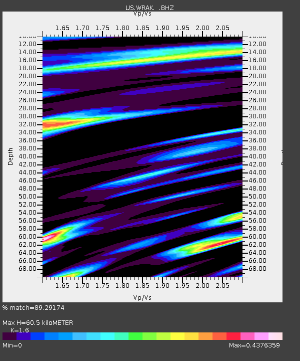
| Estimated Moho Depth: |
60.5 km |
| Estimated Crust Vp/Vs: |
1.60 |
| Assumed Crust Vp: |
6.597 km/s |
| Estimated Crust Vs: |
4.123 km/s |
| Estimated Crust Poisson's Ratio: |
0.18 |
|
| Radial Match: |
89.29174 % |
| Radial Bump: |
400 |
| Transverse Match: |
69.98347 % |
| Transverse Bump: |
400 |
| SOD ConfigId: |
346946 |
| Insert Time: |
2011-07-09 11:37:15.932 +0000 |
| GWidth: |
2.5 |
| Max Bumps: |
400 |
| Tol: |
0.001 |
|

Signal To Noise
| Channel | StoN | STA | LTA |
| US:WRAK: :BHZ:20110113T16:29:16.224998Z | 5.3426056 | 2.8291709E-6 | 5.2954886E-7 |
| US:WRAK: :BHN:20110113T16:29:16.224998Z | 1.9270648 | 6.149778E-7 | 3.191267E-7 |
| US:WRAK: :BHE:20110113T16:29:16.224998Z | 2.7462592 | 8.4286347E-7 | 3.0691328E-7 |
| Arrivals |
| Ps | 5.6 SECOND |
| PpPs | 23 SECOND |
| PsPs/PpSs | 29 SECOND |


