You are here: Home > Network List > CI - Caltech Regional Seismic Network Stations List
> Station VTV Victorville, California, USA > Earthquake Result Viewer
VTV Victorville, California, USA - Earthquake Result Viewer
| Earthquake location: |
Loyalty Islands |
| Earthquake latitude/longitude: |
-20.6/168.4 |
| Earthquake time(UTC): |
2011/01/13 (013) 16:43:07 GMT |
| Earthquake Depth: |
10 km |
| Earthquake Magnitude: |
5.9 MB, 5.9 MW |
| Earthquake Catalog/Contributor: |
WHDF/NEIC |
|
| Network: |
CI Caltech Regional Seismic Network |
| Station: |
VTV Victorville, California, USA |
| Lat/Lon: |
34.56 N/117.33 W |
| Elevation: |
812 m |
|
| Distance: |
89.3 deg |
| Az: |
52.604 deg |
| Baz: |
244.394 deg |
| Ray Param: |
0.041942134 |
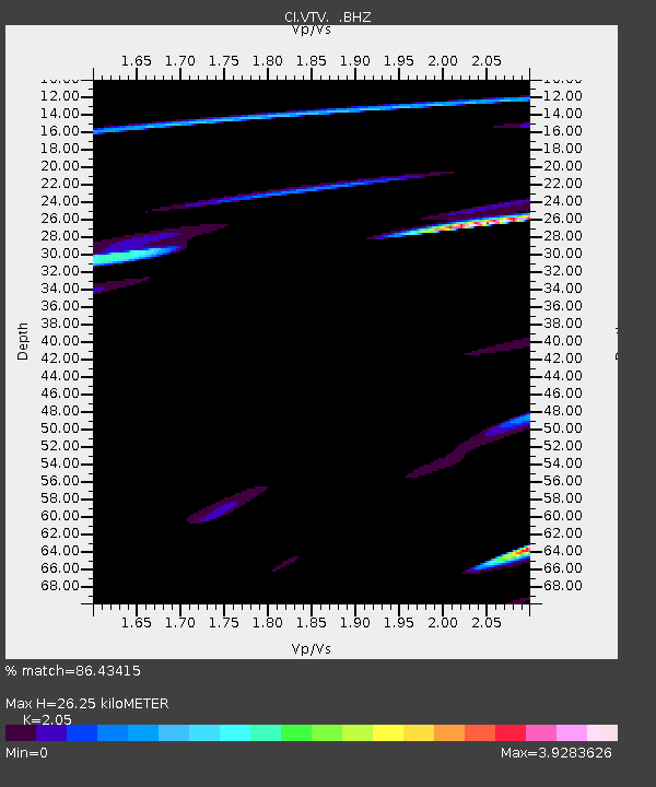
| Estimated Moho Depth: |
26.25 km |
| Estimated Crust Vp/Vs: |
2.05 |
| Assumed Crust Vp: |
6.276 km/s |
| Estimated Crust Vs: |
3.061 km/s |
| Estimated Crust Poisson's Ratio: |
0.34 |
|
| Radial Match: |
86.43415 % |
| Radial Bump: |
314 |
| Transverse Match: |
51.325054 % |
| Transverse Bump: |
366 |
| SOD ConfigId: |
346946 |
| Insert Time: |
2011-07-09 12:05:13.134 +0000 |
| GWidth: |
2.5 |
| Max Bumps: |
400 |
| Tol: |
0.001 |
|

Signal To Noise
| Channel | StoN | STA | LTA |
| CI:VTV: :BHZ:20110113T16:55:32.555012Z | 3.5640059 | 3.0103928E-7 | 8.446655E-8 |
| CI:VTV: :BHN:20110113T16:55:32.555012Z | 0.7454855 | 2.2217546E-6 | 2.9802789E-6 |
| CI:VTV: :BHE:20110113T16:55:32.555012Z | 1.0989219 | 2.8451998E-6 | 2.5890827E-6 |
| Arrivals |
| Ps | 4.5 SECOND |
| PpPs | 13 SECOND |
| PsPs/PpSs | 17 SECOND |


