You are here: Home > Network List > TA - USArray Transportable Network (new EarthScope stations) Stations List
> Station Y12C Blythe, CA, USA > Earthquake Result Viewer
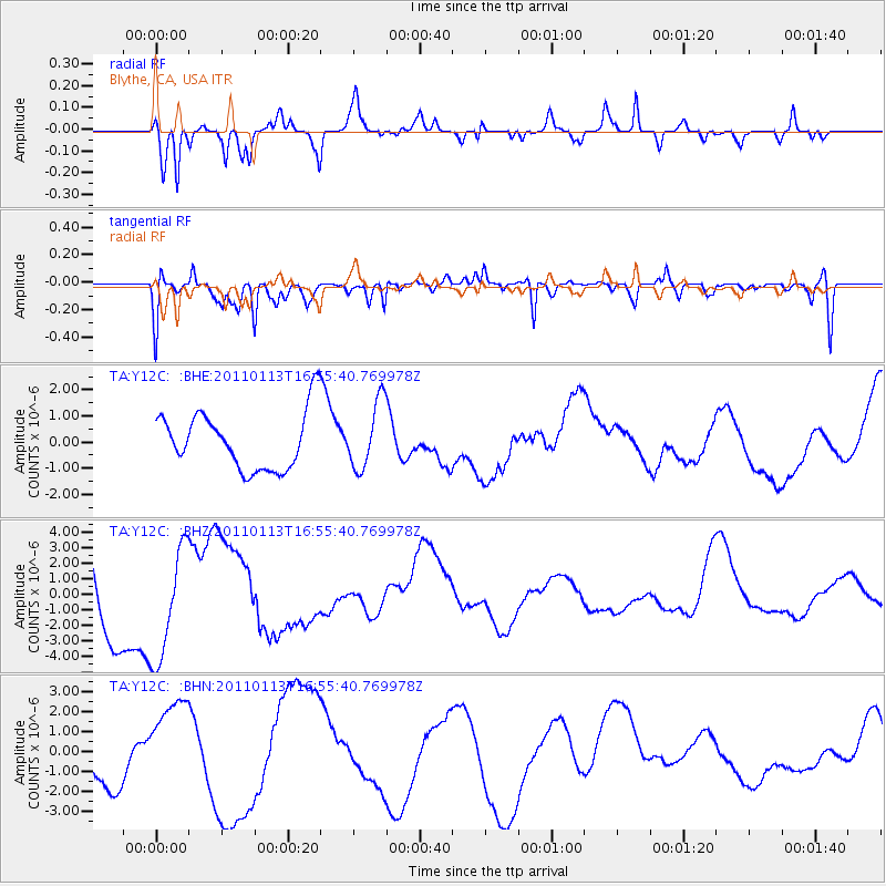
Y12C Blythe, CA, USA - Earthquake Result Viewer
*The percent match for this event was below the threshold and hence no stack was calculated.
| Earthquake location: |
Loyalty Islands |
| Earthquake latitude/longitude: |
-20.6/168.4 |
| Earthquake time(UTC): |
2011/01/13 (013) 16:43:07 GMT |
| Earthquake Depth: |
10 km |
| Earthquake Magnitude: |
5.9 MB, 5.9 MW |
| Earthquake Catalog/Contributor: |
WHDF/NEIC |
|
| Network: |
TA USArray Transportable Network (new EarthScope stations) |
| Station: |
Y12C Blythe, CA, USA |
| Lat/Lon: |
33.75 N/114.52 W |
| Elevation: |
196 m |
|
| Distance: |
91.1 deg |
| Az: |
54.314 deg |
| Baz: |
245.956 deg |
| Ray Param: |
$rayparam |
*The percent match for this event was below the threshold and hence was not used in the summary stack. |
|
| Radial Match: |
65.7963 % |
| Radial Bump: |
318 |
| Transverse Match: |
59.610313 % |
| Transverse Bump: |
400 |
| SOD ConfigId: |
346946 |
| Insert Time: |
2011-07-09 12:14:17.271 +0000 |
| GWidth: |
2.5 |
| Max Bumps: |
400 |
| Tol: |
0.001 |
|
Signal To Noise
| Channel | StoN | STA | LTA |
| TA:Y12C: :BHZ:20110113T16:55:40.769978Z | 1.4313855 | 3.6153642E-6 | 2.5257796E-6 |
| TA:Y12C: :BHN:20110113T16:55:40.769978Z | 1.2723807 | 2.500408E-6 | 1.9651416E-6 |
| TA:Y12C: :BHE:20110113T16:55:40.769978Z | 1.1768899 | 1.2885879E-6 | 1.0949094E-6 |
| Arrivals |
| Ps | |
| PpPs | |
| PsPs/PpSs | |


