You are here: Home > Network List > AZ - ANZA Regional Network Stations List
> Station FRD AZ.FRD > Earthquake Result Viewer
FRD AZ.FRD - Earthquake Result Viewer
*The percent match for this event was below the threshold and hence no stack was calculated.
| Earthquake location: |
Kermadec Islands Region |
| Earthquake latitude/longitude: |
-31.2/179.6 |
| Earthquake time(UTC): |
1997/03/21 (080) 12:07:17 GMT |
| Earthquake Depth: |
449 km |
| Earthquake Magnitude: |
5.6 MB, 6.3 UNKNOWN, 6.2 MW |
| Earthquake Catalog/Contributor: |
WHDF/NEIC |
|
| Network: |
AZ ANZA Regional Network |
| Station: |
FRD AZ.FRD |
| Lat/Lon: |
33.49 N/116.60 W |
| Elevation: |
1164 m |
|
| Distance: |
88.1 deg |
| Az: |
48.594 deg |
| Baz: |
230.302 deg |
| Ray Param: |
$rayparam |
*The percent match for this event was below the threshold and hence was not used in the summary stack. |
|
| Radial Match: |
74.330315 % |
| Radial Bump: |
400 |
| Transverse Match: |
62.437965 % |
| Transverse Bump: |
400 |
| SOD ConfigId: |
4480 |
| Insert Time: |
2010-02-26 19:22:38.671 +0000 |
| GWidth: |
2.5 |
| Max Bumps: |
400 |
| Tol: |
0.001 |
|
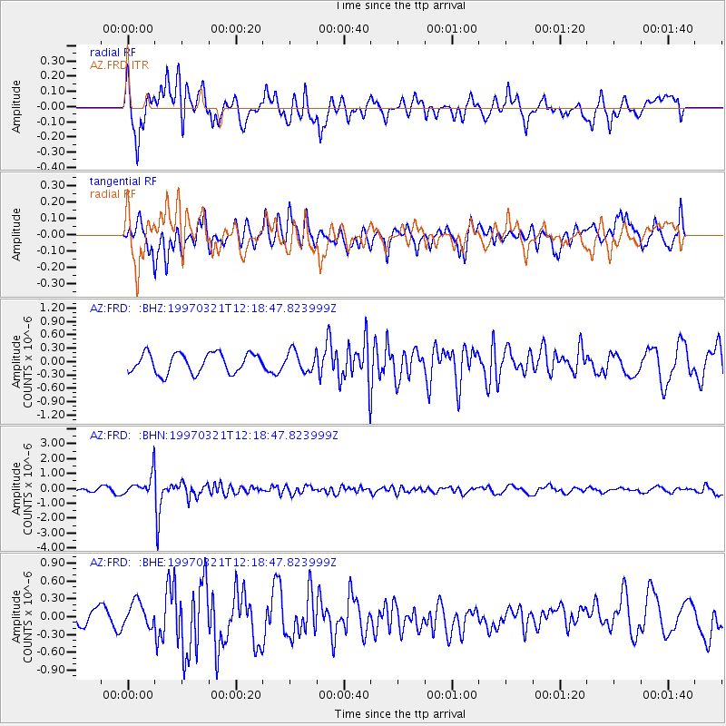
Signal To Noise
| Channel | StoN | STA | LTA |
| AZ:FRD: :BHN:19970321T12:18:47.823999Z | 2.669417 | 7.391467E-7 | 2.7689444E-7 |
| AZ:FRD: :BHE:19970321T12:18:47.823999Z | 1.1923124 | 2.2535127E-7 | 1.8900356E-7 |
| AZ:FRD: :BHZ:19970321T12:18:47.823999Z | 1.0434979 | 2.2969658E-7 | 2.2012175E-7 |
| Arrivals |
| Ps | |
| PpPs | |
| PsPs/PpSs | |


