You are here: Home > Network List > XL12 - Hangay Dome, Mongolia Stations List
> Station HD11 HD11 > Earthquake Result Viewer
HD11 HD11 - Earthquake Result Viewer
| Earthquake location: |
Bonin Islands, Japan Region |
| Earthquake latitude/longitude: |
28.9/142.3 |
| Earthquake time(UTC): |
2014/01/18 (018) 05:00:43 GMT |
| Earthquake Depth: |
18 km |
| Earthquake Magnitude: |
5.5 MW |
| Earthquake Catalog/Contributor: |
ISC/ISC |
|
| Network: |
XL Hangay Dome, Mongolia |
| Station: |
HD11 HD11 |
| Lat/Lon: |
46.59 N/100.91 E |
| Elevation: |
2233 m |
|
| Distance: |
36.7 deg |
| Az: |
310.218 deg |
| Baz: |
103.948 deg |
| Ray Param: |
0.076525636 |
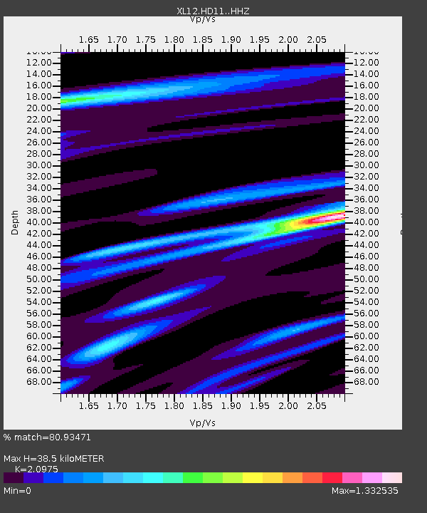
| Estimated Moho Depth: |
38.5 km |
| Estimated Crust Vp/Vs: |
2.10 |
| Assumed Crust Vp: |
6.642 km/s |
| Estimated Crust Vs: |
3.167 km/s |
| Estimated Crust Poisson's Ratio: |
0.35 |
|
| Radial Match: |
80.93471 % |
| Radial Bump: |
400 |
| Transverse Match: |
32.430748 % |
| Transverse Bump: |
400 |
| SOD ConfigId: |
3390531 |
| Insert Time: |
2019-04-10 00:55:41.505 +0000 |
| GWidth: |
2.5 |
| Max Bumps: |
400 |
| Tol: |
0.001 |
|

Signal To Noise
| Channel | StoN | STA | LTA |
| XL:HD11: :HHZ:20140118T05:07:18.369006Z | 3.3018305 | 2.7277298E-7 | 8.261266E-8 |
| XL:HD11: :HHN:20140118T05:07:18.369006Z | 0.5534216 | 5.5642868E-8 | 1.0054336E-7 |
| XL:HD11: :HHE:20140118T05:07:18.369006Z | 1.8649023 | 1.07970855E-7 | 5.7896255E-8 |
| Arrivals |
| Ps | 6.8 SECOND |
| PpPs | 17 SECOND |
| PsPs/PpSs | 24 SECOND |


