You are here: Home > Network List > KN - Kyrgyz Seismic Telemetry Network Stations List
> Station TKM2 KN.TKM2 > Earthquake Result Viewer
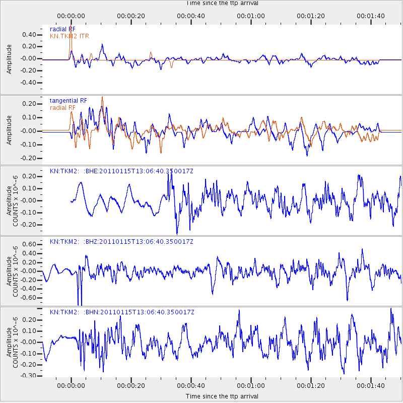
TKM2 KN.TKM2 - Earthquake Result Viewer
*The percent match for this event was below the threshold and hence no stack was calculated.
| Earthquake location: |
Banda Sea |
| Earthquake latitude/longitude: |
-5.7/130.3 |
| Earthquake time(UTC): |
2011/01/15 (015) 12:56:26 GMT |
| Earthquake Depth: |
199 km |
| Earthquake Magnitude: |
5.5 MB, 5.7 MW, 5.7 MW |
| Earthquake Catalog/Contributor: |
WHDF/NEIC |
|
| Network: |
KN Kyrgyz Seismic Telemetry Network |
| Station: |
TKM2 KN.TKM2 |
| Lat/Lon: |
42.92 N/75.60 E |
| Elevation: |
2020 m |
|
| Distance: |
69.1 deg |
| Az: |
320.109 deg |
| Baz: |
119.671 deg |
| Ray Param: |
$rayparam |
*The percent match for this event was below the threshold and hence was not used in the summary stack. |
|
| Radial Match: |
50.763733 % |
| Radial Bump: |
400 |
| Transverse Match: |
54.858665 % |
| Transverse Bump: |
400 |
| SOD ConfigId: |
346946 |
| Insert Time: |
2011-07-12 07:24:31.451 +0000 |
| GWidth: |
2.5 |
| Max Bumps: |
400 |
| Tol: |
0.001 |
|
Signal To Noise
| Channel | StoN | STA | LTA |
| KN:TKM2: :BHZ:20110115T13:06:40.350017Z | 1.9553804 | 2.2364642E-7 | 1.143749E-7 |
| KN:TKM2: :BHN:20110115T13:06:40.350017Z | 1.2547636 | 8.2890175E-8 | 6.606039E-8 |
| KN:TKM2: :BHE:20110115T13:06:40.350017Z | 1.546861 | 1.00398346E-7 | 6.490456E-8 |
| Arrivals |
| Ps | |
| PpPs | |
| PsPs/PpSs | |


