You are here: Home > Network List > YB13 - Continental Dynamics/Cent. Anatolian Tectonics:Surface to Mantle Dynamics During Stations List
> Station AT24 Sarikaya,Kayseri,Turkey > Earthquake Result Viewer
AT24 Sarikaya,Kayseri,Turkey - Earthquake Result Viewer
| Earthquake location: |
Bonin Islands, Japan Region |
| Earthquake latitude/longitude: |
28.9/142.3 |
| Earthquake time(UTC): |
2014/01/18 (018) 05:00:43 GMT |
| Earthquake Depth: |
18 km |
| Earthquake Magnitude: |
5.5 MW |
| Earthquake Catalog/Contributor: |
ISC/ISC |
|
| Network: |
YB Continental Dynamics/Cent. Anatolian Tectonics:Surface to Mantle Dynamics During |
| Station: |
AT24 Sarikaya,Kayseri,Turkey |
| Lat/Lon: |
38.16 N/35.90 E |
| Elevation: |
1683 m |
|
| Distance: |
84.2 deg |
| Az: |
310.538 deg |
| Baz: |
57.677 deg |
| Ray Param: |
0.045632623 |
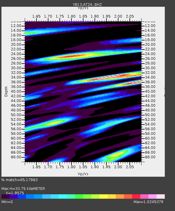
| Estimated Moho Depth: |
33.75 km |
| Estimated Crust Vp/Vs: |
1.96 |
| Assumed Crust Vp: |
6.35 km/s |
| Estimated Crust Vs: |
3.244 km/s |
| Estimated Crust Poisson's Ratio: |
0.32 |
|
| Radial Match: |
85.17963 % |
| Radial Bump: |
400 |
| Transverse Match: |
74.77671 % |
| Transverse Bump: |
400 |
| SOD ConfigId: |
3390531 |
| Insert Time: |
2019-04-10 00:56:35.310 +0000 |
| GWidth: |
2.5 |
| Max Bumps: |
400 |
| Tol: |
0.001 |
|

Signal To Noise
| Channel | StoN | STA | LTA |
| YB:AT24: :BHZ:20140118T05:12:42.160022Z | 9.982302 | 4.4800507E-7 | 4.4879936E-8 |
| YB:AT24: :BHN:20140118T05:12:42.160022Z | 2.5460467 | 1.15713995E-7 | 4.54485E-8 |
| YB:AT24: :BHE:20140118T05:12:42.160022Z | 2.6543517 | 1.1942629E-7 | 4.499264E-8 |
| Arrivals |
| Ps | 5.2 SECOND |
| PpPs | 15 SECOND |
| PsPs/PpSs | 21 SECOND |


