You are here: Home > Network List > G - GEOSCOPE Stations List
> Station INU Inuyama, Japan > Earthquake Result Viewer
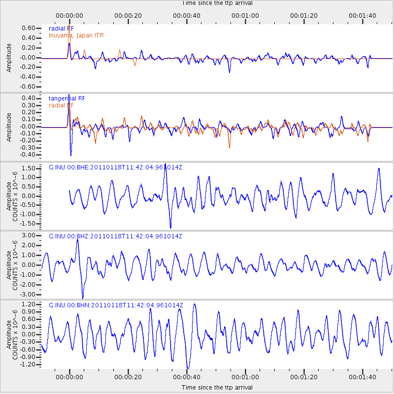
INU Inuyama, Japan - Earthquake Result Viewer
*The percent match for this event was below the threshold and hence no stack was calculated.
| Earthquake location: |
Northern Sumatra, Indonesia |
| Earthquake latitude/longitude: |
2.6/96.4 |
| Earthquake time(UTC): |
2011/01/18 (018) 11:33:44 GMT |
| Earthquake Depth: |
17 km |
| Earthquake Magnitude: |
5.7 MB, 5.9 MS, 5.9 MW, 5.9 MW |
| Earthquake Catalog/Contributor: |
WHDF/NEIC |
|
| Network: |
G GEOSCOPE |
| Station: |
INU Inuyama, Japan |
| Lat/Lon: |
35.35 N/137.03 E |
| Elevation: |
132 m |
|
| Distance: |
49.8 deg |
| Az: |
44.215 deg |
| Baz: |
238.45 deg |
| Ray Param: |
$rayparam |
*The percent match for this event was below the threshold and hence was not used in the summary stack. |
|
| Radial Match: |
66.673096 % |
| Radial Bump: |
400 |
| Transverse Match: |
73.5945 % |
| Transverse Bump: |
400 |
| SOD ConfigId: |
346946 |
| Insert Time: |
2011-07-12 07:47:35.630 +0000 |
| GWidth: |
2.5 |
| Max Bumps: |
400 |
| Tol: |
0.001 |
|
Signal To Noise
| Channel | StoN | STA | LTA |
| G:INU:00:BHZ:20110118T11:42:04.961014Z | 2.1409497 | 1.4944093E-6 | 6.980123E-7 |
| G:INU:00:BHN:20110118T11:42:04.961014Z | 1.2473652 | 4.6508126E-7 | 3.728509E-7 |
| G:INU:00:BHE:20110118T11:42:04.961014Z | 1.9184991 | 8.3903063E-7 | 4.3733698E-7 |
| Arrivals |
| Ps | |
| PpPs | |
| PsPs/PpSs | |


