You are here: Home > Network List > G - GEOSCOPE Stations List
> Station FOMA Nahampoana reservation, Fort Dauphin, Madagascar > Earthquake Result Viewer
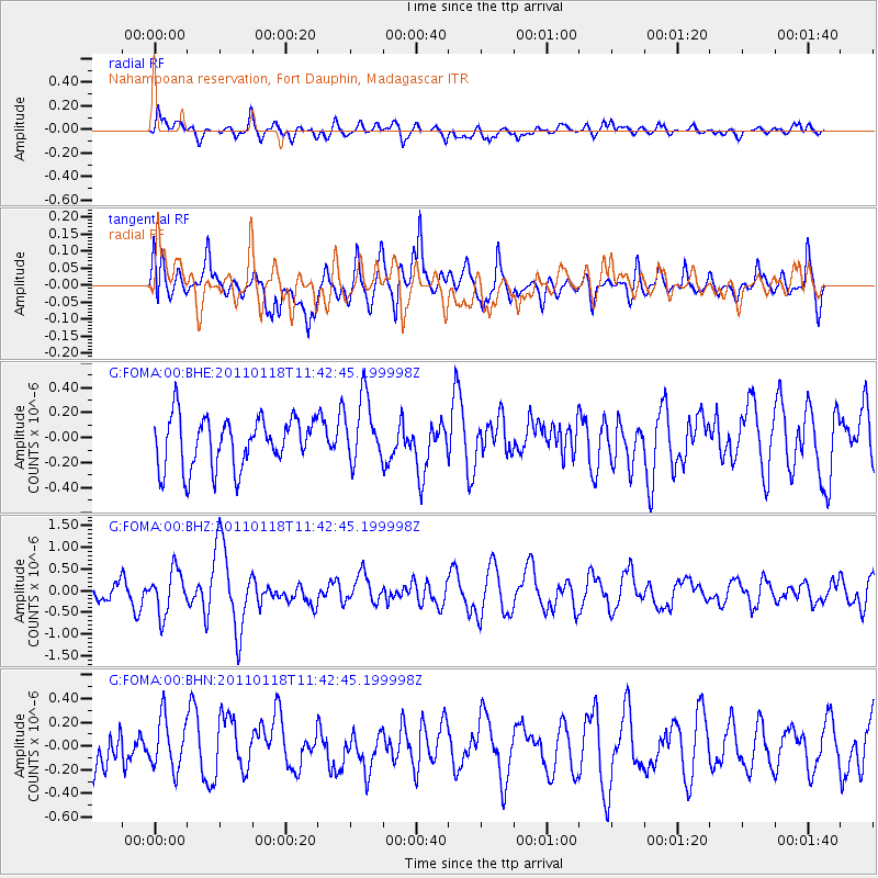
FOMA Nahampoana reservation, Fort Dauphin, Madagascar - Earthquake Result Viewer
*The percent match for this event was below the threshold and hence no stack was calculated.
| Earthquake location: |
Northern Sumatra, Indonesia |
| Earthquake latitude/longitude: |
2.6/96.4 |
| Earthquake time(UTC): |
2011/01/18 (018) 11:33:44 GMT |
| Earthquake Depth: |
17 km |
| Earthquake Magnitude: |
5.7 MB, 5.9 MS, 5.9 MW, 5.9 MW |
| Earthquake Catalog/Contributor: |
WHDF/NEIC |
|
| Network: |
G GEOSCOPE |
| Station: |
FOMA Nahampoana reservation, Fort Dauphin, Madagascar |
| Lat/Lon: |
24.98 S/46.98 E |
| Elevation: |
26 m |
|
| Distance: |
55.2 deg |
| Az: |
237.073 deg |
| Baz: |
67.502 deg |
| Ray Param: |
$rayparam |
*The percent match for this event was below the threshold and hence was not used in the summary stack. |
|
| Radial Match: |
55.12196 % |
| Radial Bump: |
400 |
| Transverse Match: |
55.404755 % |
| Transverse Bump: |
400 |
| SOD ConfigId: |
346946 |
| Insert Time: |
2011-07-12 07:47:44.095 +0000 |
| GWidth: |
2.5 |
| Max Bumps: |
400 |
| Tol: |
0.001 |
|
Signal To Noise
| Channel | StoN | STA | LTA |
| G:FOMA:00:BHZ:20110118T11:42:45.199998Z | 2.267469 | 4.92568E-7 | 2.1723253E-7 |
| G:FOMA:00:BHN:20110118T11:42:45.199998Z | 1.1109252 | 2.1673955E-7 | 1.9509825E-7 |
| G:FOMA:00:BHE:20110118T11:42:45.199998Z | 1.2993186 | 2.6089384E-7 | 2.0079283E-7 |
| Arrivals |
| Ps | |
| PpPs | |
| PsPs/PpSs | |


