You are here: Home > Network List > AU - Australian Seismological Centre Stations List
> Station QIS Mount Isa, Queensland > Earthquake Result Viewer
QIS Mount Isa, Queensland - Earthquake Result Viewer
| Earthquake location: |
Southwestern Pakistan |
| Earthquake latitude/longitude: |
28.8/64.0 |
| Earthquake time(UTC): |
2011/01/18 (018) 20:23:23 GMT |
| Earthquake Depth: |
68 km |
| Earthquake Magnitude: |
6.7 MB, 7.2 MW, 7.1 MW |
| Earthquake Catalog/Contributor: |
WHDF/NEIC |
|
| Network: |
AU Australian Seismological Centre |
| Station: |
QIS Mount Isa, Queensland |
| Lat/Lon: |
20.56 S/139.61 E |
| Elevation: |
450 m |
|
| Distance: |
87.9 deg |
| Az: |
114.704 deg |
| Baz: |
301.673 deg |
| Ray Param: |
0.042857446 |
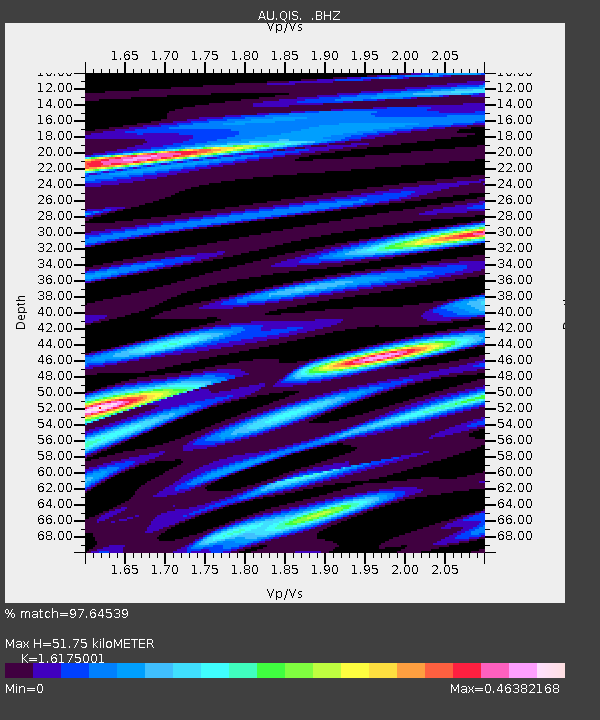
| Estimated Moho Depth: |
51.75 km |
| Estimated Crust Vp/Vs: |
1.62 |
| Assumed Crust Vp: |
6.577 km/s |
| Estimated Crust Vs: |
4.066 km/s |
| Estimated Crust Poisson's Ratio: |
0.19 |
|
| Radial Match: |
97.64539 % |
| Radial Bump: |
400 |
| Transverse Match: |
97.926956 % |
| Transverse Bump: |
343 |
| SOD ConfigId: |
346946 |
| Insert Time: |
2011-07-12 08:02:29.021 +0000 |
| GWidth: |
2.5 |
| Max Bumps: |
400 |
| Tol: |
0.001 |
|

Signal To Noise
| Channel | StoN | STA | LTA |
| AU:QIS: :BHZ:20110118T20:35:34.445027Z | 47.76327 | 6.2588083E-6 | 1.3103809E-7 |
| AU:QIS: :BHN:20110118T20:35:34.445027Z | 4.7722507 | 7.419984E-7 | 1.5548186E-7 |
| AU:QIS: :BHE:20110118T20:35:34.445027Z | 19.12339 | 2.0771101E-6 | 1.08616206E-7 |
| Arrivals |
| Ps | 5.0 SECOND |
| PpPs | 20 SECOND |
| PsPs/PpSs | 25 SECOND |


