You are here: Home > Network List > AU - Australian Seismological Centre Stations List
> Station XMI Christmas Island Airport > Earthquake Result Viewer
XMI Christmas Island Airport - Earthquake Result Viewer
| Earthquake location: |
Southwestern Pakistan |
| Earthquake latitude/longitude: |
28.8/64.0 |
| Earthquake time(UTC): |
2011/01/18 (018) 20:23:23 GMT |
| Earthquake Depth: |
68 km |
| Earthquake Magnitude: |
6.7 MB, 7.2 MW, 7.1 MW |
| Earthquake Catalog/Contributor: |
WHDF/NEIC |
|
| Network: |
AU Australian Seismological Centre |
| Station: |
XMI Christmas Island Airport |
| Lat/Lon: |
10.45 S/105.69 E |
| Elevation: |
252 m |
|
| Distance: |
56.1 deg |
| Az: |
127.897 deg |
| Baz: |
315.23 deg |
| Ray Param: |
0.06419199 |
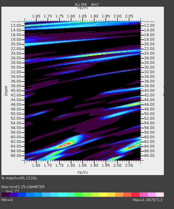
| Estimated Moho Depth: |
63.25 km |
| Estimated Crust Vp/Vs: |
1.77 |
| Assumed Crust Vp: |
4.157 km/s |
| Estimated Crust Vs: |
2.348 km/s |
| Estimated Crust Poisson's Ratio: |
0.27 |
|
| Radial Match: |
95.22281 % |
| Radial Bump: |
254 |
| Transverse Match: |
92.78011 % |
| Transverse Bump: |
384 |
| SOD ConfigId: |
346946 |
| Insert Time: |
2011-07-12 08:05:20.383 +0000 |
| GWidth: |
2.5 |
| Max Bumps: |
400 |
| Tol: |
0.001 |
|

Signal To Noise
| Channel | StoN | STA | LTA |
| AU:XMI: :BHZ:20110118T20:32:24.96999Z | 17.846786 | 2.0617319E-5 | 1.1552398E-6 |
| AU:XMI: :BHN:20110118T20:32:24.96999Z | 6.397008 | 7.572571E-6 | 1.1837677E-6 |
| AU:XMI: :BHE:20110118T20:32:24.96999Z | 4.704554 | 6.67303E-6 | 1.4184192E-6 |
| Arrivals |
| Ps | 12 SECOND |
| PpPs | 41 SECOND |
| PsPs/PpSs | 53 SECOND |


