You are here: Home > Network List > CN - Canadian National Seismograph Network Stations List
> Station FRB Iqaluit, Nunavut Territory, Canada > Earthquake Result Viewer
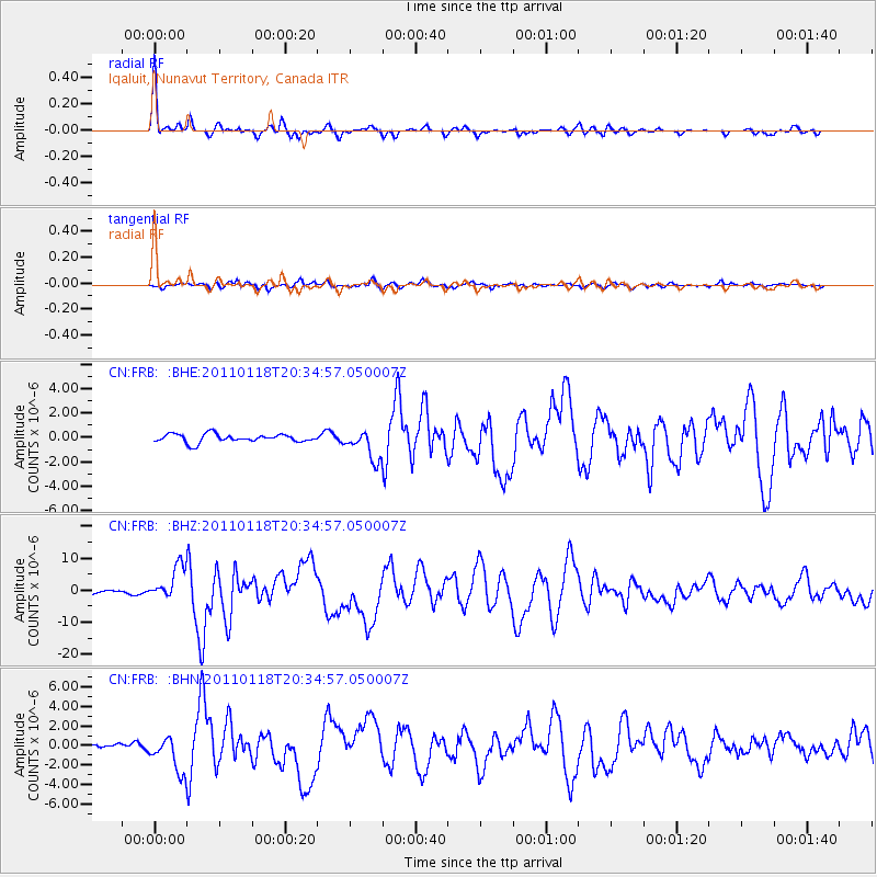
FRB Iqaluit, Nunavut Territory, Canada - Earthquake Result Viewer

| Earthquake location: |
Southwestern Pakistan |
| Earthquake latitude/longitude: |
28.8/64.0 |
| Earthquake time(UTC): |
2011/01/18 (018) 20:23:23 GMT |
| Earthquake Depth: |
68 km |
| Earthquake Magnitude: |
6.7 MB, 7.2 MW, 7.1 MW |
| Earthquake Catalog/Contributor: |
WHDF/NEIC |
|
| Network: |
CN Canadian National Seismograph Network |
| Station: |
FRB Iqaluit, Nunavut Territory, Canada |
| Lat/Lon: |
63.75 N/68.55 W |
| Elevation: |
25 m |
|
| Distance: |
80.5 deg |
| Az: |
340.581 deg |
| Baz: |
41.017 deg |
| Ray Param: |
0.04810662 |
| Estimated Moho Depth: |
47.5 km |
| Estimated Crust Vp/Vs: |
1.73 |
| Assumed Crust Vp: |
6.419 km/s |
| Estimated Crust Vs: |
3.711 km/s |
| Estimated Crust Poisson's Ratio: |
0.25 |
|
| Radial Match: |
95.543 % |
| Radial Bump: |
303 |
| Transverse Match: |
74.77043 % |
| Transverse Bump: |
400 |
| SOD ConfigId: |
346946 |
| Insert Time: |
2011-07-12 08:07:31.480 +0000 |
| GWidth: |
2.5 |
| Max Bumps: |
400 |
| Tol: |
0.001 |
|
Signal To Noise
| Channel | StoN | STA | LTA |
| CN:FRB: :BHZ:20110118T20:34:57.050007Z | 8.748006 | 5.329151E-6 | 6.091846E-7 |
| CN:FRB: :BHN:20110118T20:34:57.050007Z | 3.0723648 | 1.8447408E-6 | 6.0043027E-7 |
| CN:FRB: :BHE:20110118T20:34:57.050007Z | 3.6544752 | 1.2247116E-6 | 3.3512651E-7 |
| Arrivals |
| Ps | 5.6 SECOND |
| PpPs | 20 SECOND |
| PsPs/PpSs | 25 SECOND |


