You are here: Home > Network List > G - GEOSCOPE Stations List
> Station SSB Saint Sauveur Badole, France > Earthquake Result Viewer
SSB Saint Sauveur Badole, France - Earthquake Result Viewer

| Earthquake location: |
Southwestern Pakistan |
| Earthquake latitude/longitude: |
28.8/64.0 |
| Earthquake time(UTC): |
2011/01/18 (018) 20:23:23 GMT |
| Earthquake Depth: |
68 km |
| Earthquake Magnitude: |
6.7 MB, 7.2 MW, 7.1 MW |
| Earthquake Catalog/Contributor: |
WHDF/NEIC |
|
| Network: |
G GEOSCOPE |
| Station: |
SSB Saint Sauveur Badole, France |
| Lat/Lon: |
45.28 N/4.54 E |
| Elevation: |
700 m |
|
| Distance: |
49.1 deg |
| Az: |
306.492 deg |
| Baz: |
88.351 deg |
| Ray Param: |
0.0687117 |
| Estimated Moho Depth: |
27.25 km |
| Estimated Crust Vp/Vs: |
1.65 |
| Assumed Crust Vp: |
6.1 km/s |
| Estimated Crust Vs: |
3.691 km/s |
| Estimated Crust Poisson's Ratio: |
0.21 |
|
| Radial Match: |
96.98312 % |
| Radial Bump: |
289 |
| Transverse Match: |
85.14587 % |
| Transverse Bump: |
400 |
| SOD ConfigId: |
346946 |
| Insert Time: |
2011-07-12 08:08:40.275 +0000 |
| GWidth: |
2.5 |
| Max Bumps: |
400 |
| Tol: |
0.001 |
|
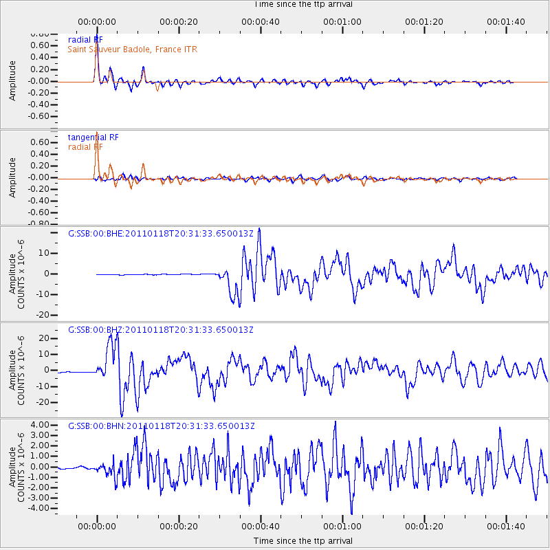
Signal To Noise
| Channel | StoN | STA | LTA |
| G:SSB:00:BHZ:20110118T20:31:33.650013Z | 31.313658 | 1.2269108E-5 | 3.9181333E-7 |
| G:SSB:00:BHN:20110118T20:31:33.650013Z | 3.7482088 | 6.973543E-7 | 1.8605003E-7 |
| G:SSB:00:BHE:20110118T20:31:33.650013Z | 43.93556 | 7.355421E-6 | 1.6741384E-7 |
| Arrivals |
| Ps | 3.1 SECOND |
| PpPs | 11 SECOND |
| PsPs/PpSs | 14 SECOND |


