You are here: Home > Network List > G - GEOSCOPE Stations List
> Station RER Riviere de l'Est, La Reunion (Indian Ocean) > Earthquake Result Viewer
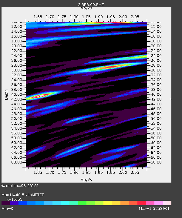
RER Riviere de l'Est, La Reunion (Indian Ocean) - Earthquake Result Viewer
| Earthquake location: |
Southwestern Pakistan |
| Earthquake latitude/longitude: |
28.8/64.0 |
| Earthquake time(UTC): |
2011/01/18 (018) 20:23:23 GMT |
| Earthquake Depth: |
68 km |
| Earthquake Magnitude: |
6.7 MB, 7.2 MW, 7.1 MW |
| Earthquake Catalog/Contributor: |
WHDF/NEIC |
|
| Network: |
G GEOSCOPE |
| Station: |
RER Riviere de l'Est, La Reunion (Indian Ocean) |
| Lat/Lon: |
21.16 S/55.75 E |
| Elevation: |
834 m |
|
| Distance: |
50.3 deg |
| Az: |
189.974 deg |
| Baz: |
9.375 deg |
| Ray Param: |
0.06796441 |
| Estimated Moho Depth: |
40.5 km |
| Estimated Crust Vp/Vs: |
1.65 |
| Assumed Crust Vp: |
4.73 km/s |
| Estimated Crust Vs: |
2.858 km/s |
| Estimated Crust Poisson's Ratio: |
0.21 |
|
| Radial Match: |
95.23181 % |
| Radial Bump: |
368 |
| Transverse Match: |
93.25394 % |
| Transverse Bump: |
356 |
| SOD ConfigId: |
346946 |
| Insert Time: |
2011-07-12 08:08:52.036 +0000 |
| GWidth: |
2.5 |
| Max Bumps: |
400 |
| Tol: |
0.001 |
|

Signal To Noise
| Channel | StoN | STA | LTA |
| G:RER:00:BHZ:20110118T20:31:42.550007Z | 9.253501 | 8.449375E-6 | 9.131003E-7 |
| G:RER:00:BHN:20110118T20:31:42.550007Z | 4.7465086 | 2.5087916E-6 | 5.285552E-7 |
| G:RER:00:BHE:20110118T20:31:42.550007Z | 1.0417868 | 4.742384E-7 | 4.5521637E-7 |
| Arrivals |
| Ps | 5.8 SECOND |
| PpPs | 22 SECOND |
| PsPs/PpSs | 28 SECOND |


