You are here: Home > Network List > G - GEOSCOPE Stations List
> Station CLF Chambon la Foret observatory, France > Earthquake Result Viewer
CLF Chambon la Foret observatory, France - Earthquake Result Viewer
| Earthquake location: |
Southwestern Pakistan |
| Earthquake latitude/longitude: |
28.8/64.0 |
| Earthquake time(UTC): |
2011/01/18 (018) 20:23:23 GMT |
| Earthquake Depth: |
68 km |
| Earthquake Magnitude: |
6.7 MB, 7.2 MW, 7.1 MW |
| Earthquake Catalog/Contributor: |
WHDF/NEIC |
|
| Network: |
G GEOSCOPE |
| Station: |
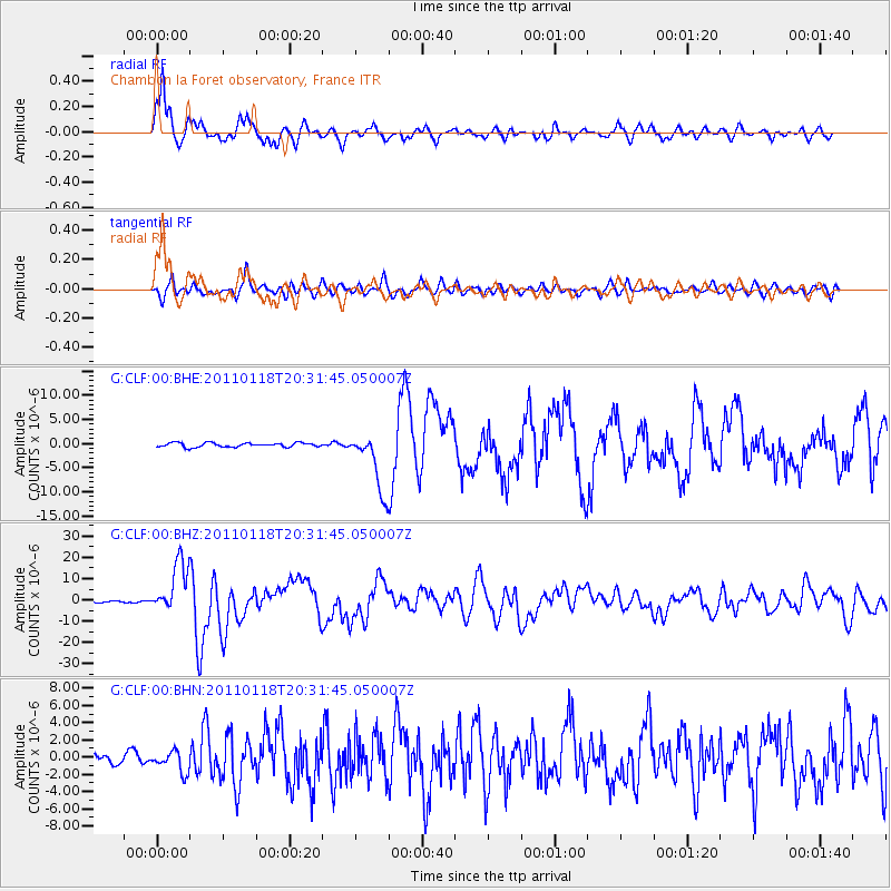
CLF Chambon la Foret observatory, France |
| Lat/Lon: |
48.03 N/2.26 E |
| Elevation: |
145 m |
|
| Distance: |
50.6 deg |
| Az: |
310.131 deg |
| Baz: |
89.042 deg |
| Ray Param: |
0.06773514 |
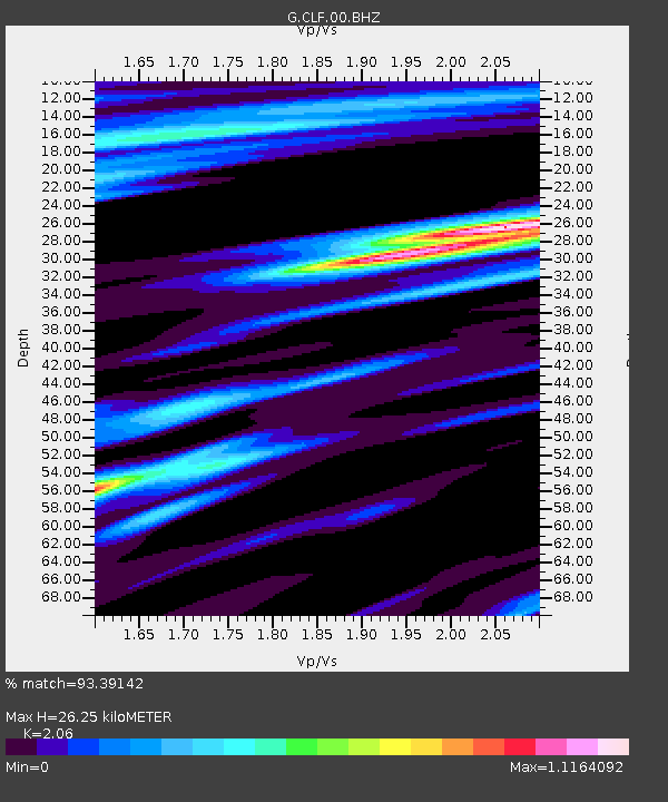
| Estimated Moho Depth: |
26.25 km |
| Estimated Crust Vp/Vs: |
2.06 |
| Assumed Crust Vp: |
6.12 km/s |
| Estimated Crust Vs: |
2.971 km/s |
| Estimated Crust Poisson's Ratio: |
0.35 |
|
| Radial Match: |
93.39142 % |
| Radial Bump: |
365 |
| Transverse Match: |
78.00872 % |
| Transverse Bump: |
400 |
| SOD ConfigId: |
346946 |
| Insert Time: |
2011-07-12 08:09:14.855 +0000 |
| GWidth: |
2.5 |
| Max Bumps: |
400 |
| Tol: |
0.001 |
|
Signal To Noise
| Channel | StoN | STA | LTA |
| G:CLF:00:BHZ:20110118T20:31:45.050007Z | 30.805525 | 1.1934427E-5 | 3.874119E-7 |
| G:CLF:00:BHN:20110118T20:31:45.050007Z | 2.5311935 | 1.2299245E-6 | 4.85907E-7 |
| G:CLF:00:BHE:20110118T20:31:45.050007Z | 14.345303 | 6.244431E-6 | 4.3529448E-7 |
| Arrivals |
| Ps | 4.8 SECOND |
| PpPs | 13 SECOND |
| PsPs/PpSs | 17 SECOND |


