You are here: Home > Network List > GT - Global Telemetered Seismograph Network (USAF/USGS) Stations List
> Station BOSA Boshof, South Africa > Earthquake Result Viewer
BOSA Boshof, South Africa - Earthquake Result Viewer
| Earthquake location: |
Southwestern Pakistan |
| Earthquake latitude/longitude: |
28.8/64.0 |
| Earthquake time(UTC): |
2011/01/18 (018) 20:23:23 GMT |
| Earthquake Depth: |
68 km |
| Earthquake Magnitude: |
6.7 MB, 7.2 MW, 7.1 MW |
| Earthquake Catalog/Contributor: |
WHDF/NEIC |
|
| Network: |
GT Global Telemetered Seismograph Network (USAF/USGS) |
| Station: |
BOSA Boshof, South Africa |
| Lat/Lon: |
28.61 S/25.26 E |
| Elevation: |
1280 m |
|
| Distance: |
68.0 deg |
| Az: |
216.351 deg |
| Baz: |
36.286 deg |
| Ray Param: |
0.056418475 |
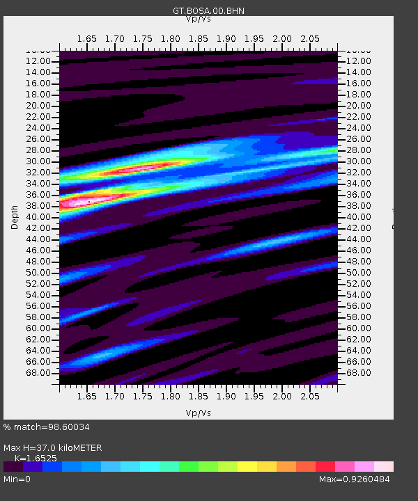
| Estimated Moho Depth: |
37.0 km |
| Estimated Crust Vp/Vs: |
1.65 |
| Assumed Crust Vp: |
6.459 km/s |
| Estimated Crust Vs: |
3.909 km/s |
| Estimated Crust Poisson's Ratio: |
0.21 |
|
| Radial Match: |
98.60034 % |
| Radial Bump: |
266 |
| Transverse Match: |
82.875534 % |
| Transverse Bump: |
400 |
| SOD ConfigId: |
346946 |
| Insert Time: |
2011-07-12 08:10:41.200 +0000 |
| GWidth: |
2.5 |
| Max Bumps: |
400 |
| Tol: |
0.001 |
|
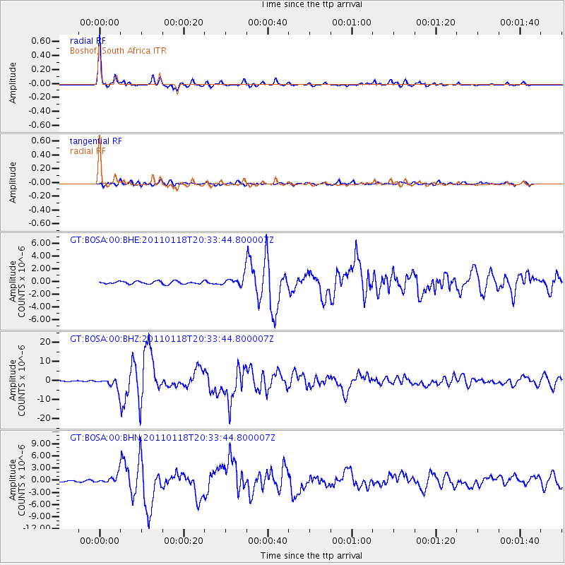
Signal To Noise
| Channel | StoN | STA | LTA |
| GT:BOSA:00:BHZ:20110118T20:33:44.800007Z | 11.173088 | 2.8965726E-6 | 2.592455E-7 |
| GT:BOSA:00:BHN:20110118T20:33:44.800007Z | 5.1453223 | 1.1402243E-6 | 2.2160405E-7 |
| GT:BOSA:00:BHE:20110118T20:33:44.800007Z | 3.9177873 | 8.626225E-7 | 2.2018106E-7 |
| Arrivals |
| Ps | 3.9 SECOND |
| PpPs | 15 SECOND |
| PsPs/PpSs | 18 SECOND |


