You are here: Home > Network List > NE - New England Seismic Network Stations List
> Station PQI Presque Isle, ME > Earthquake Result Viewer
PQI Presque Isle, ME - Earthquake Result Viewer
| Earthquake location: |
Southwestern Pakistan |
| Earthquake latitude/longitude: |
28.8/64.0 |
| Earthquake time(UTC): |
2011/01/18 (018) 20:23:23 GMT |
| Earthquake Depth: |
68 km |
| Earthquake Magnitude: |
6.7 MB, 7.2 MW, 7.1 MW |
| Earthquake Catalog/Contributor: |
WHDF/NEIC |
|
| Network: |
NE New England Seismic Network |
| Station: |
PQI Presque Isle, ME |
| Lat/Lon: |
46.67 N/68.01 W |
| Elevation: |
175 m |
|
| Distance: |
93.3 deg |
| Az: |
329.145 deg |
| Baz: |
40.829 deg |
| Ray Param: |
0.041262023 |
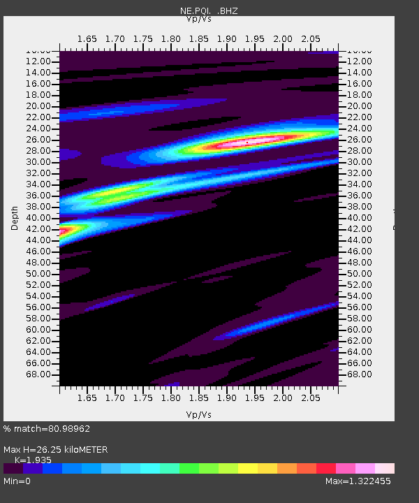
| Estimated Moho Depth: |
26.25 km |
| Estimated Crust Vp/Vs: |
1.93 |
| Assumed Crust Vp: |
6.419 km/s |
| Estimated Crust Vs: |
3.317 km/s |
| Estimated Crust Poisson's Ratio: |
0.32 |
|
| Radial Match: |
80.98962 % |
| Radial Bump: |
343 |
| Transverse Match: |
71.34655 % |
| Transverse Bump: |
400 |
| SOD ConfigId: |
346946 |
| Insert Time: |
2011-07-12 08:17:57.324 +0000 |
| GWidth: |
2.5 |
| Max Bumps: |
400 |
| Tol: |
0.001 |
|
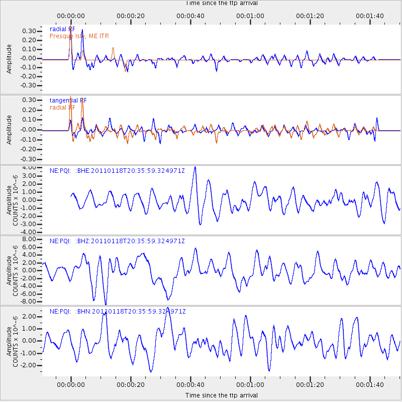
Signal To Noise
| Channel | StoN | STA | LTA |
| NE:PQI: :BHZ:20110118T20:35:59.324971Z | 2.3802276 | 2.3926336E-6 | 1.0052121E-6 |
| NE:PQI: :BHN:20110118T20:35:59.324971Z | 1.5568086 | 9.052141E-7 | 5.8145497E-7 |
| NE:PQI: :BHE:20110118T20:35:59.324971Z | 0.929429 | 6.524917E-7 | 7.0203504E-7 |
| Arrivals |
| Ps | 3.9 SECOND |
| PpPs | 12 SECOND |
| PsPs/PpSs | 16 SECOND |


