You are here: Home > Network List > US - United States National Seismic Network Stations List
> Station EGAK Eagle, Central Alaska, Alaska, USA > Earthquake Result Viewer
EGAK Eagle, Central Alaska, Alaska, USA - Earthquake Result Viewer

| Earthquake location: |
Southwestern Pakistan |
| Earthquake latitude/longitude: |
28.8/64.0 |
| Earthquake time(UTC): |
2011/01/18 (018) 20:23:23 GMT |
| Earthquake Depth: |
68 km |
| Earthquake Magnitude: |
6.7 MB, 7.2 MW, 7.1 MW |
| Earthquake Catalog/Contributor: |
WHDF/NEIC |
|
| Network: |
US United States National Seismic Network |
| Station: |
EGAK Eagle, Central Alaska, Alaska, USA |
| Lat/Lon: |
64.78 N/141.16 W |
| Elevation: |
297 m |
|
| Distance: |
84.7 deg |
| Az: |
10.521 deg |
| Baz: |
338.031 deg |
| Ray Param: |
0.045152433 |
| Estimated Moho Depth: |
30.0 km |
| Estimated Crust Vp/Vs: |
1.97 |
| Assumed Crust Vp: |
6.566 km/s |
| Estimated Crust Vs: |
3.329 km/s |
| Estimated Crust Poisson's Ratio: |
0.33 |
|
| Radial Match: |
93.34875 % |
| Radial Bump: |
325 |
| Transverse Match: |
86.78634 % |
| Transverse Bump: |
400 |
| SOD ConfigId: |
346946 |
| Insert Time: |
2011-07-12 08:21:57.582 +0000 |
| GWidth: |
2.5 |
| Max Bumps: |
400 |
| Tol: |
0.001 |
|
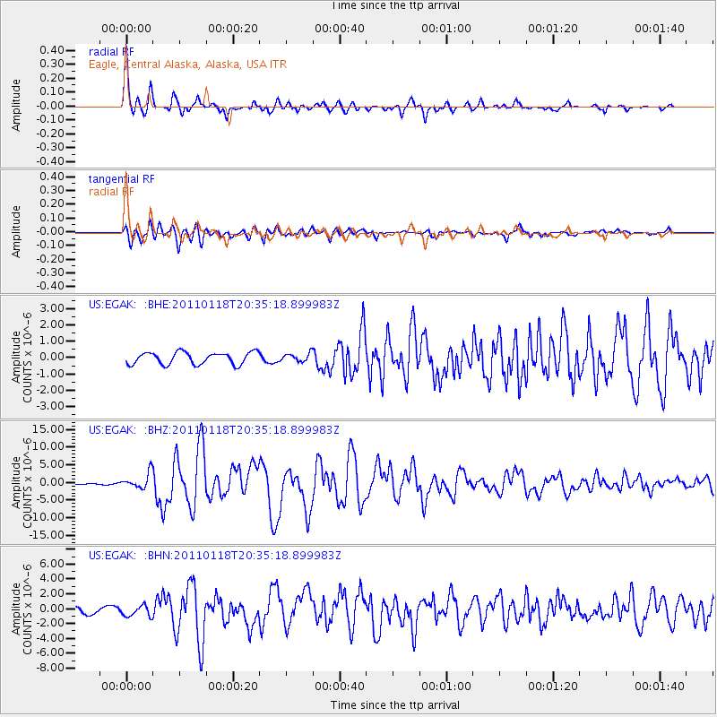
Signal To Noise
| Channel | StoN | STA | LTA |
| US:EGAK: :BHZ:20110118T20:35:18.899983Z | 5.0612063 | 2.2231013E-6 | 4.3924337E-7 |
| US:EGAK: :BHN:20110118T20:35:18.899983Z | 2.30147 | 7.366257E-7 | 3.2006744E-7 |
| US:EGAK: :BHE:20110118T20:35:18.899983Z | 0.68336016 | 2.5007472E-7 | 3.6594864E-7 |
| Arrivals |
| Ps | 4.5 SECOND |
| PpPs | 13 SECOND |
| PsPs/PpSs | 18 SECOND |


