You are here: Home > Network List > IU - Global Seismograph Network (GSN - IRIS/USGS) Stations List
> Station RSSD Black Hills, South Dakota, USA > Earthquake Result Viewer
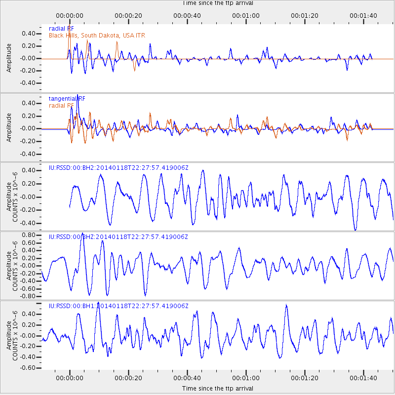
RSSD Black Hills, South Dakota, USA - Earthquake Result Viewer
*The percent match for this event was below the threshold and hence no stack was calculated.
| Earthquake location: |
Northern Mid-Atlantic Ridge |
| Earthquake latitude/longitude: |
26.3/-44.4 |
| Earthquake time(UTC): |
2014/01/18 (018) 22:19:28 GMT |
| Earthquake Depth: |
11 km |
| Earthquake Magnitude: |
5.4 MW |
| Earthquake Catalog/Contributor: |
ISC/ISC |
|
| Network: |
IU Global Seismograph Network (GSN - IRIS/USGS) |
| Station: |
RSSD Black Hills, South Dakota, USA |
| Lat/Lon: |
44.12 N/104.04 W |
| Elevation: |
2090 m |
|
| Distance: |
50.7 deg |
| Az: |
306.628 deg |
| Baz: |
89.793 deg |
| Ray Param: |
$rayparam |
*The percent match for this event was below the threshold and hence was not used in the summary stack. |
|
| Radial Match: |
71.220406 % |
| Radial Bump: |
400 |
| Transverse Match: |
69.05261 % |
| Transverse Bump: |
400 |
| SOD ConfigId: |
3390531 |
| Insert Time: |
2019-04-10 01:02:39.348 +0000 |
| GWidth: |
2.5 |
| Max Bumps: |
400 |
| Tol: |
0.001 |
|
Signal To Noise
| Channel | StoN | STA | LTA |
| IU:RSSD:00:BHZ:20140118T22:27:57.419006Z | 2.0342171 | 4.639883E-7 | 2.2809182E-7 |
| IU:RSSD:00:BH1:20140118T22:27:57.419006Z | 1.8595437 | 2.1297302E-7 | 1.14529726E-7 |
| IU:RSSD:00:BH2:20140118T22:27:57.419006Z | 1.2056708 | 2.0972735E-7 | 1.7395075E-7 |
| Arrivals |
| Ps | |
| PpPs | |
| PsPs/PpSs | |


