You are here: Home > Network List > AZ - ANZA Regional Network Stations List
> Station FRD AZ.FRD > Earthquake Result Viewer
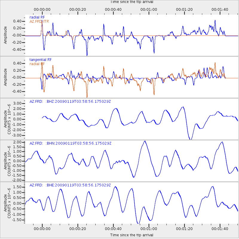
FRD AZ.FRD - Earthquake Result Viewer
*The percent match for this event was below the threshold and hence no stack was calculated.
| Earthquake location: |
Southeast Of Loyalty Islands |
| Earthquake latitude/longitude: |
-22.5/170.8 |
| Earthquake time(UTC): |
2009/01/19 (019) 03:46:37 GMT |
| Earthquake Depth: |
35 km |
| Earthquake Magnitude: |
6.0 MW, 5.3 MB |
| Earthquake Catalog/Contributor: |
WHDF/NEIC |
|
| Network: |
AZ ANZA Regional Network |
| Station: |
FRD AZ.FRD |
| Lat/Lon: |
33.49 N/116.60 W |
| Elevation: |
1164 m |
|
| Distance: |
88.7 deg |
| Az: |
52.898 deg |
| Baz: |
241.981 deg |
| Ray Param: |
$rayparam |
*The percent match for this event was below the threshold and hence was not used in the summary stack. |
|
| Radial Match: |
31.696243 % |
| Radial Bump: |
400 |
| Transverse Match: |
51.396473 % |
| Transverse Bump: |
366 |
| SOD ConfigId: |
2658 |
| Insert Time: |
2010-02-26 19:23:50.448 +0000 |
| GWidth: |
2.5 |
| Max Bumps: |
400 |
| Tol: |
0.001 |
|
Signal To Noise
| Channel | StoN | STA | LTA |
| AZ:FRD: :BHN:20090119T03:58:56.175029Z | 0.9420477 | 4.0261986E-7 | 4.2738796E-7 |
| AZ:FRD: :BHE:20090119T03:58:56.175029Z | 0.459594 | 4.164848E-7 | 9.062015E-7 |
| AZ:FRD: :BHZ:20090119T03:58:56.175029Z | 1.6948596 | 8.420194E-7 | 4.968078E-7 |
| Arrivals |
| Ps | |
| PpPs | |
| PsPs/PpSs | |


