You are here: Home > Network List > UW - Pacific Northwest Regional Seismic Network Stations List
> Station WOLL Wollman Farm, Schrag, WA, USA > Earthquake Result Viewer
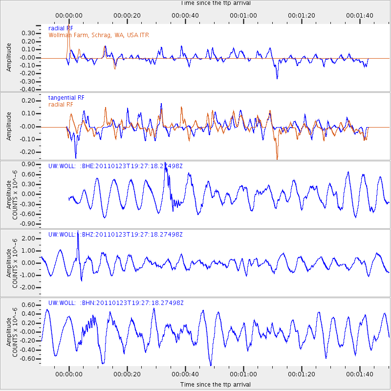
WOLL Wollman Farm, Schrag, WA, USA - Earthquake Result Viewer
*The percent match for this event was below the threshold and hence no stack was calculated.
| Earthquake location: |
Fiji Islands Region |
| Earthquake latitude/longitude: |
-20.3/-176.3 |
| Earthquake time(UTC): |
2011/01/23 (023) 19:15:42 GMT |
| Earthquake Depth: |
236 km |
| Earthquake Magnitude: |
5.7 MB, 5.9 MW, 5.9 MW |
| Earthquake Catalog/Contributor: |
WHDF/NEIC |
|
| Network: |
UW Pacific Northwest Regional Seismic Network |
| Station: |
WOLL Wollman Farm, Schrag, WA, USA |
| Lat/Lon: |
47.06 N/118.92 W |
| Elevation: |
385 m |
|
| Distance: |
84.6 deg |
| Az: |
35.336 deg |
| Baz: |
232.545 deg |
| Ray Param: |
$rayparam |
*The percent match for this event was below the threshold and hence was not used in the summary stack. |
|
| Radial Match: |
53.314526 % |
| Radial Bump: |
400 |
| Transverse Match: |
45.467 % |
| Transverse Bump: |
389 |
| SOD ConfigId: |
346946 |
| Insert Time: |
2011-07-14 07:36:19.134 +0000 |
| GWidth: |
2.5 |
| Max Bumps: |
400 |
| Tol: |
0.001 |
|
Signal To Noise
| Channel | StoN | STA | LTA |
| UW:WOLL: :BHZ:20110123T19:27:18.27498Z | 2.480093 | 9.0652884E-7 | 3.655221E-7 |
| UW:WOLL: :BHN:20110123T19:27:18.27498Z | 1.0175738 | 2.6522355E-7 | 2.6064305E-7 |
| UW:WOLL: :BHE:20110123T19:27:18.27498Z | 1.5654352 | 4.8430104E-7 | 3.093715E-7 |
| Arrivals |
| Ps | |
| PpPs | |
| PsPs/PpSs | |


