You are here: Home > Network List > TA - USArray Transportable Network (new EarthScope stations) Stations List
> Station F49A Sandfield, ON, CAN > Earthquake Result Viewer
F49A Sandfield, ON, CAN - Earthquake Result Viewer
| Earthquake location: |
Northern Mid-Atlantic Ridge |
| Earthquake latitude/longitude: |
26.3/-44.4 |
| Earthquake time(UTC): |
2014/01/18 (018) 22:19:28 GMT |
| Earthquake Depth: |
11 km |
| Earthquake Magnitude: |
5.4 MW |
| Earthquake Catalog/Contributor: |
ISC/ISC |
|
| Network: |
TA USArray Transportable Network (new EarthScope stations) |
| Station: |
F49A Sandfield, ON, CAN |
| Lat/Lon: |
45.76 N/82.04 W |
| Elevation: |
230 m |
|
| Distance: |
35.6 deg |
| Az: |
312.839 deg |
| Baz: |
109.945 deg |
| Ray Param: |
0.07711128 |
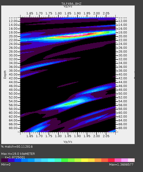
| Estimated Moho Depth: |
19.0 km |
| Estimated Crust Vp/Vs: |
1.87 |
| Assumed Crust Vp: |
6.483 km/s |
| Estimated Crust Vs: |
3.462 km/s |
| Estimated Crust Poisson's Ratio: |
0.30 |
|
| Radial Match: |
80.112816 % |
| Radial Bump: |
334 |
| Transverse Match: |
43.44442 % |
| Transverse Bump: |
400 |
| SOD ConfigId: |
3390531 |
| Insert Time: |
2019-04-10 01:04:37.263 +0000 |
| GWidth: |
2.5 |
| Max Bumps: |
400 |
| Tol: |
0.001 |
|
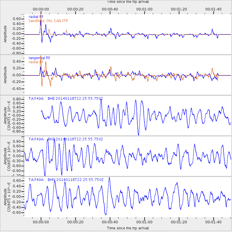
Signal To Noise
| Channel | StoN | STA | LTA |
| TA:F49A: :BHZ:20140118T22:25:55.750Z | 2.672078 | 6.3219943E-7 | 2.3659467E-7 |
| TA:F49A: :BHN:20140118T22:25:55.750Z | 0.6543826 | 2.1059935E-7 | 3.218291E-7 |
| TA:F49A: :BHE:20140118T22:25:55.750Z | 1.2102067 | 3.332837E-7 | 2.7539403E-7 |
| Arrivals |
| Ps | 2.8 SECOND |
| PpPs | 7.8 SECOND |
| PsPs/PpSs | 11 SECOND |


