You are here: Home > Network List > TA - USArray Transportable Network (new EarthScope stations) Stations List
> Station N32A Stulken Farm, Doniphan, NE, USA > Earthquake Result Viewer
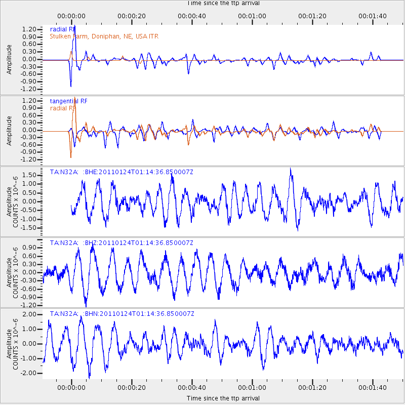
N32A Stulken Farm, Doniphan, NE, USA - Earthquake Result Viewer
*The percent match for this event was below the threshold and hence no stack was calculated.
| Earthquake location: |
Tonga Islands |
| Earthquake latitude/longitude: |
-19.2/-173.5 |
| Earthquake time(UTC): |
2011/01/24 (024) 01:02:02 GMT |
| Earthquake Depth: |
16 km |
| Earthquake Magnitude: |
5.5 MB, 5.8 MS, 5.7 MW, 5.7 MW |
| Earthquake Catalog/Contributor: |
WHDF/NEIC |
|
| Network: |
TA USArray Transportable Network (new EarthScope stations) |
| Station: |
N32A Stulken Farm, Doniphan, NE, USA |
| Lat/Lon: |
40.76 N/98.30 W |
| Elevation: |
587 m |
|
| Distance: |
91.7 deg |
| Az: |
47.285 deg |
| Baz: |
246.084 deg |
| Ray Param: |
$rayparam |
*The percent match for this event was below the threshold and hence was not used in the summary stack. |
|
| Radial Match: |
79.37803 % |
| Radial Bump: |
400 |
| Transverse Match: |
64.680855 % |
| Transverse Bump: |
376 |
| SOD ConfigId: |
346946 |
| Insert Time: |
2011-07-14 07:47:27.309 +0000 |
| GWidth: |
2.5 |
| Max Bumps: |
400 |
| Tol: |
0.001 |
|
Signal To Noise
| Channel | StoN | STA | LTA |
| TA:N32A: :BHZ:20110124T01:14:36.850007Z | 2.0447617 | 5.9286634E-7 | 2.8994398E-7 |
| TA:N32A: :BHN:20110124T01:14:36.850007Z | 1.7200526 | 1.147611E-6 | 6.671953E-7 |
| TA:N32A: :BHE:20110124T01:14:36.850007Z | 1.4759269 | 8.8813556E-7 | 6.017477E-7 |
| Arrivals |
| Ps | |
| PpPs | |
| PsPs/PpSs | |


