You are here: Home > Network List > TA - USArray Transportable Network (new EarthScope stations) Stations List
> Station V32A Arapaho, OK, USA > Earthquake Result Viewer
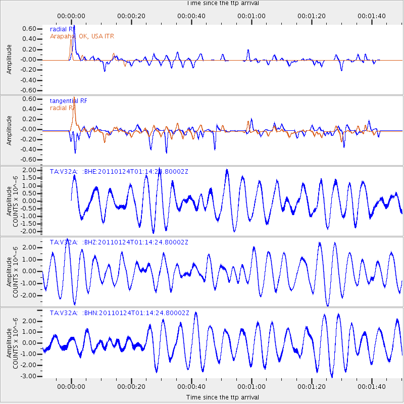
V32A Arapaho, OK, USA - Earthquake Result Viewer
*The percent match for this event was below the threshold and hence no stack was calculated.
| Earthquake location: |
Tonga Islands |
| Earthquake latitude/longitude: |
-19.2/-173.5 |
| Earthquake time(UTC): |
2011/01/24 (024) 01:02:02 GMT |
| Earthquake Depth: |
16 km |
| Earthquake Magnitude: |
5.5 MB, 5.8 MS, 5.7 MW, 5.7 MW |
| Earthquake Catalog/Contributor: |
WHDF/NEIC |
|
| Network: |
TA USArray Transportable Network (new EarthScope stations) |
| Station: |
V32A Arapaho, OK, USA |
| Lat/Lon: |
35.72 N/99.04 W |
| Elevation: |
533 m |
|
| Distance: |
89.1 deg |
| Az: |
51.638 deg |
| Baz: |
245.593 deg |
| Ray Param: |
$rayparam |
*The percent match for this event was below the threshold and hence was not used in the summary stack. |
|
| Radial Match: |
52.70506 % |
| Radial Bump: |
304 |
| Transverse Match: |
70.16963 % |
| Transverse Bump: |
382 |
| SOD ConfigId: |
346946 |
| Insert Time: |
2011-07-14 07:48:14.178 +0000 |
| GWidth: |
2.5 |
| Max Bumps: |
400 |
| Tol: |
0.001 |
|
Signal To Noise
| Channel | StoN | STA | LTA |
| TA:V32A: :BHZ:20110124T01:14:24.80002Z | 2.648301 | 1.6429661E-6 | 6.2038504E-7 |
| TA:V32A: :BHN:20110124T01:14:24.80002Z | 0.9876207 | 6.1050486E-7 | 6.1815723E-7 |
| TA:V32A: :BHE:20110124T01:14:24.80002Z | 1.5591563 | 1.2388507E-6 | 7.945648E-7 |
| Arrivals |
| Ps | |
| PpPs | |
| PsPs/PpSs | |


