You are here: Home > Network List > UW - Pacific Northwest Regional Seismic Network Stations List
> Station HOOD Mt Hood Meadows, OR CREST BB SMO > Earthquake Result Viewer
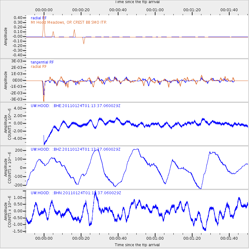
HOOD Mt Hood Meadows, OR CREST BB SMO - Earthquake Result Viewer
*The percent match for this event was below the threshold and hence no stack was calculated.
| Earthquake location: |
Tonga Islands |
| Earthquake latitude/longitude: |
-19.2/-173.5 |
| Earthquake time(UTC): |
2011/01/24 (024) 01:02:02 GMT |
| Earthquake Depth: |
16 km |
| Earthquake Magnitude: |
5.5 MB, 5.8 MS, 5.7 MW, 5.7 MW |
| Earthquake Catalog/Contributor: |
WHDF/NEIC |
|
| Network: |
UW Pacific Northwest Regional Seismic Network |
| Station: |
HOOD Mt Hood Meadows, OR CREST BB SMO |
| Lat/Lon: |
45.32 N/121.65 W |
| Elevation: |
1520 m |
|
| Distance: |
79.6 deg |
| Az: |
34.339 deg |
| Baz: |
229.077 deg |
| Ray Param: |
$rayparam |
*The percent match for this event was below the threshold and hence was not used in the summary stack. |
|
| Radial Match: |
67.00494 % |
| Radial Bump: |
338 |
| Transverse Match: |
82.593834 % |
| Transverse Bump: |
386 |
| SOD ConfigId: |
346946 |
| Insert Time: |
2011-07-14 07:54:39.708 +0000 |
| GWidth: |
2.5 |
| Max Bumps: |
400 |
| Tol: |
0.001 |
|
Signal To Noise
| Channel | StoN | STA | LTA |
| UW:HOOD: :BHZ:20110124T01:13:37.060029Z | 0.0936532 | 5.1966996E-5 | 5.548875E-4 |
| UW:HOOD: :BHN:20110124T01:13:37.060029Z | 0.7016076 | 4.0298497E-7 | 5.7437376E-7 |
| UW:HOOD: :BHE:20110124T01:13:37.060029Z | 1.1179389 | 1.643627E-6 | 1.4702298E-6 |
| Arrivals |
| Ps | |
| PpPs | |
| PsPs/PpSs | |


