You are here: Home > Network List > TA - USArray Transportable Network (new EarthScope stations) Stations List
> Station R56A Bull Pasture Mountain, McDowell, VA, USA > Earthquake Result Viewer
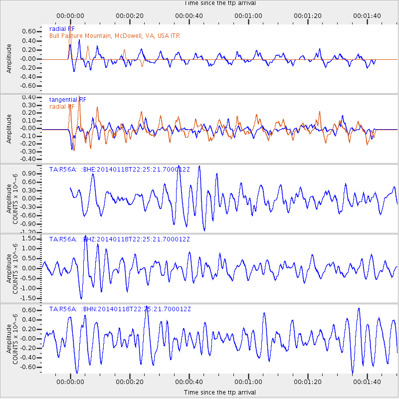
R56A Bull Pasture Mountain, McDowell, VA, USA - Earthquake Result Viewer
*The percent match for this event was below the threshold and hence no stack was calculated.
| Earthquake location: |
Northern Mid-Atlantic Ridge |
| Earthquake latitude/longitude: |
26.3/-44.4 |
| Earthquake time(UTC): |
2014/01/18 (018) 22:19:28 GMT |
| Earthquake Depth: |
11 km |
| Earthquake Magnitude: |
5.4 MW |
| Earthquake Catalog/Contributor: |
ISC/ISC |
|
| Network: |
TA USArray Transportable Network (new EarthScope stations) |
| Station: |
R56A Bull Pasture Mountain, McDowell, VA, USA |
| Lat/Lon: |
38.41 N/79.40 W |
| Elevation: |
902 m |
|
| Distance: |
31.7 deg |
| Az: |
301.054 deg |
| Baz: |
101.889 deg |
| Ray Param: |
$rayparam |
*The percent match for this event was below the threshold and hence was not used in the summary stack. |
|
| Radial Match: |
70.88818 % |
| Radial Bump: |
400 |
| Transverse Match: |
59.128883 % |
| Transverse Bump: |
396 |
| SOD ConfigId: |
3390531 |
| Insert Time: |
2019-04-10 01:05:17.178 +0000 |
| GWidth: |
2.5 |
| Max Bumps: |
400 |
| Tol: |
0.001 |
|
Signal To Noise
| Channel | StoN | STA | LTA |
| TA:R56A: :BHZ:20140118T22:25:21.700012Z | 2.3952186 | 6.967907E-7 | 2.9090904E-7 |
| TA:R56A: :BHN:20140118T22:25:21.700012Z | 1.988763 | 4.1113384E-7 | 2.0672843E-7 |
| TA:R56A: :BHE:20140118T22:25:21.700012Z | 1.1841524 | 3.4936474E-7 | 2.950336E-7 |
| Arrivals |
| Ps | |
| PpPs | |
| PsPs/PpSs | |


