You are here: Home > Network List > IU - Global Seismograph Network (GSN - IRIS/USGS) Stations List
> Station FURI Mt. Furi, Ethiopia > Earthquake Result Viewer
FURI Mt. Furi, Ethiopia - Earthquake Result Viewer

| Earthquake location: |
Tajikistan |
| Earthquake latitude/longitude: |
38.4/72.8 |
| Earthquake time(UTC): |
2011/01/24 (024) 02:45:31 GMT |
| Earthquake Depth: |
110 km |
| Earthquake Magnitude: |
6.0 MB, 6.1 MW, 6.0 MW |
| Earthquake Catalog/Contributor: |
WHDF/NEIC |
|
| Network: |
IU Global Seismograph Network (GSN - IRIS/USGS) |
| Station: |
FURI Mt. Furi, Ethiopia |
| Lat/Lon: |
8.90 N/38.68 E |
| Elevation: |
2570 m |
|
| Distance: |
42.5 deg |
| Az: |
235.172 deg |
| Baz: |
40.738 deg |
| Ray Param: |
0.07278456 |
| Estimated Moho Depth: |
45.25 km |
| Estimated Crust Vp/Vs: |
1.70 |
| Assumed Crust Vp: |
6.464 km/s |
| Estimated Crust Vs: |
3.802 km/s |
| Estimated Crust Poisson's Ratio: |
0.24 |
|
| Radial Match: |
82.496704 % |
| Radial Bump: |
400 |
| Transverse Match: |
78.151566 % |
| Transverse Bump: |
400 |
| SOD ConfigId: |
346946 |
| Insert Time: |
2011-07-14 08:02:44.580 +0000 |
| GWidth: |
2.5 |
| Max Bumps: |
400 |
| Tol: |
0.001 |
|
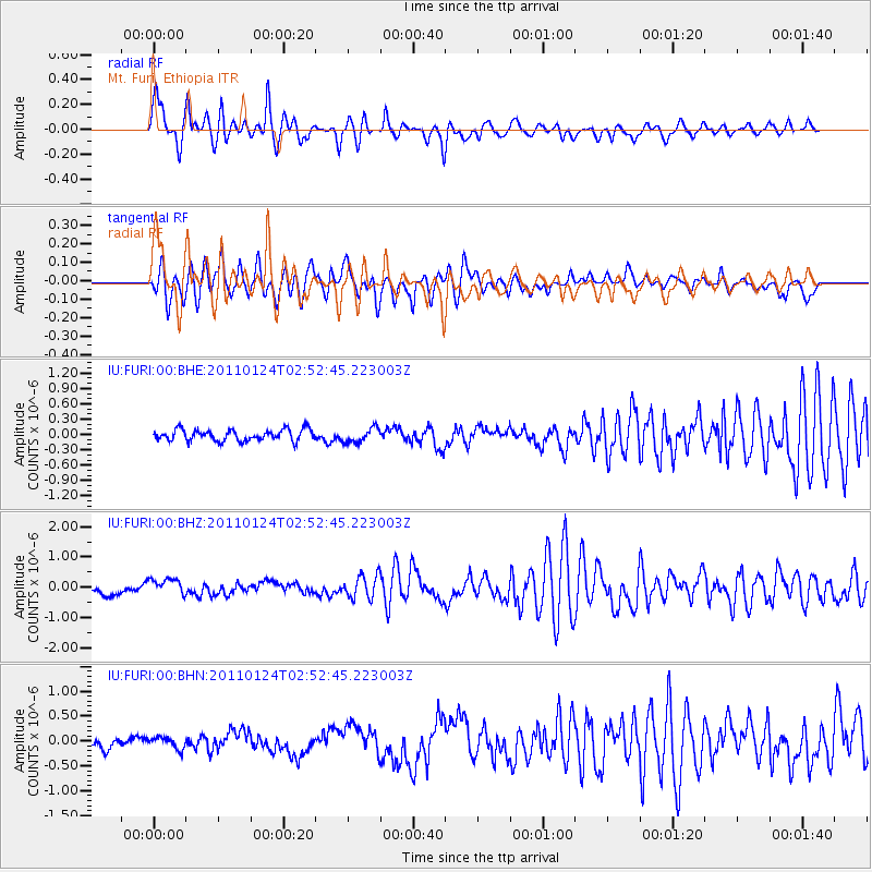
Signal To Noise
| Channel | StoN | STA | LTA |
| IU:FURI:00:BHZ:20110124T02:52:45.223003Z | 1.7751738 | 2.8549968E-7 | 1.6082915E-7 |
| IU:FURI:00:BHN:20110124T02:52:45.223003Z | 1.0627763 | 1.1604977E-7 | 1.09194914E-7 |
| IU:FURI:00:BHE:20110124T02:52:45.223003Z | 1.2794825 | 1.4123702E-7 | 1.1038605E-7 |
| Arrivals |
| Ps | 5.3 SECOND |
| PpPs | 18 SECOND |
| PsPs/PpSs | 23 SECOND |


