You are here: Home > Network List > TA - USArray Transportable Network (new EarthScope stations) Stations List
> Station TUL1 Leonard, OK, USA > Earthquake Result Viewer
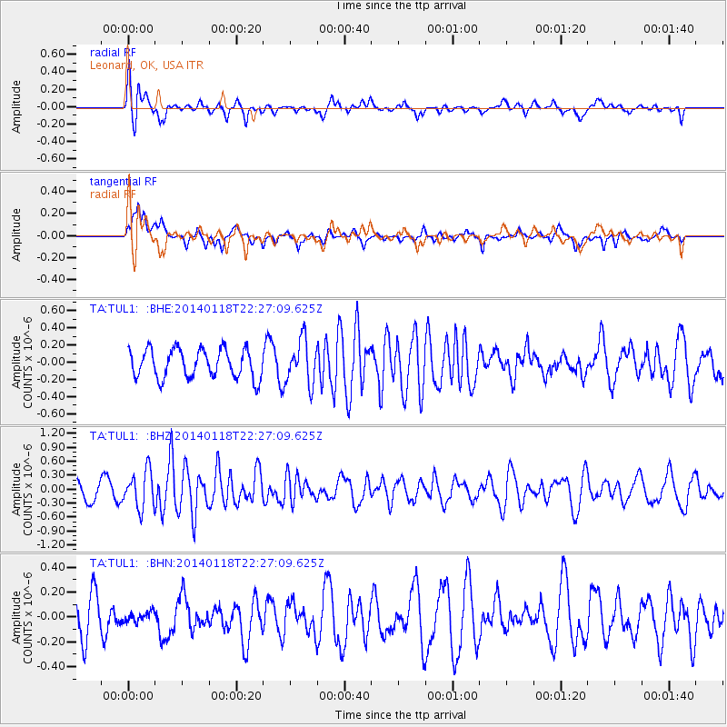
TUL1 Leonard, OK, USA - Earthquake Result Viewer
*The percent match for this event was below the threshold and hence no stack was calculated.
| Earthquake location: |
Northern Mid-Atlantic Ridge |
| Earthquake latitude/longitude: |
26.3/-44.4 |
| Earthquake time(UTC): |
2014/01/18 (018) 22:19:28 GMT |
| Earthquake Depth: |
11 km |
| Earthquake Magnitude: |
5.4 MW |
| Earthquake Catalog/Contributor: |
ISC/ISC |
|
| Network: |
TA USArray Transportable Network (new EarthScope stations) |
| Station: |
TUL1 Leonard, OK, USA |
| Lat/Lon: |
35.91 N/95.79 W |
| Elevation: |
256 m |
|
| Distance: |
44.6 deg |
| Az: |
295.348 deg |
| Baz: |
87.469 deg |
| Ray Param: |
$rayparam |
*The percent match for this event was below the threshold and hence was not used in the summary stack. |
|
| Radial Match: |
71.08912 % |
| Radial Bump: |
400 |
| Transverse Match: |
60.217564 % |
| Transverse Bump: |
400 |
| SOD ConfigId: |
3390531 |
| Insert Time: |
2019-04-10 01:05:25.478 +0000 |
| GWidth: |
2.5 |
| Max Bumps: |
400 |
| Tol: |
0.001 |
|
Signal To Noise
| Channel | StoN | STA | LTA |
| TA:TUL1: :BHZ:20140118T22:27:09.625Z | 2.1059704 | 4.0050384E-7 | 1.9017544E-7 |
| TA:TUL1: :BHN:20140118T22:27:09.625Z | 0.2553902 | 4.2780414E-8 | 1.6751E-7 |
| TA:TUL1: :BHE:20140118T22:27:09.625Z | 1.5355421 | 2.5535323E-7 | 1.6629517E-7 |
| Arrivals |
| Ps | |
| PpPs | |
| PsPs/PpSs | |


