You are here: Home > Network List > TA - USArray Transportable Network (new EarthScope stations) Stations List
> Station X43A Marvell, AR, USA > Earthquake Result Viewer
X43A Marvell, AR, USA - Earthquake Result Viewer
*The percent match for this event was below the threshold and hence no stack was calculated.
| Earthquake location: |
Northern Mid-Atlantic Ridge |
| Earthquake latitude/longitude: |
26.3/-44.4 |
| Earthquake time(UTC): |
2014/01/18 (018) 22:19:28 GMT |
| Earthquake Depth: |
11 km |
| Earthquake Magnitude: |
5.4 MW |
| Earthquake Catalog/Contributor: |
ISC/ISC |
|
| Network: |
TA USArray Transportable Network (new EarthScope stations) |
| Station: |
X43A Marvell, AR, USA |
| Lat/Lon: |
34.52 N/90.88 W |
| Elevation: |
53 m |
|
| Distance: |
40.6 deg |
| Az: |
293.095 deg |
| Baz: |
88.629 deg |
| Ray Param: |
$rayparam |
*The percent match for this event was below the threshold and hence was not used in the summary stack. |
|
| Radial Match: |
48.06915 % |
| Radial Bump: |
400 |
| Transverse Match: |
60.019455 % |
| Transverse Bump: |
400 |
| SOD ConfigId: |
3390531 |
| Insert Time: |
2019-04-10 01:05:35.710 +0000 |
| GWidth: |
2.5 |
| Max Bumps: |
400 |
| Tol: |
0.001 |
|
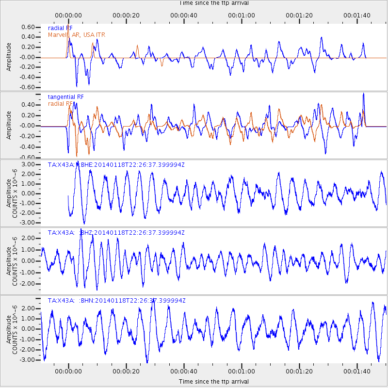
Signal To Noise
| Channel | StoN | STA | LTA |
| TA:X43A: :BHZ:20140118T22:26:37.399994Z | 1.9625597 | 1.276107E-6 | 6.5022584E-7 |
| TA:X43A: :BHN:20140118T22:26:37.399994Z | 0.61080855 | 8.5559583E-7 | 1.4007594E-6 |
| TA:X43A: :BHE:20140118T22:26:37.399994Z | 0.79663384 | 1.270052E-6 | 1.5942732E-6 |
| Arrivals |
| Ps | |
| PpPs | |
| PsPs/PpSs | |


