You are here: Home > Network List > PL - Polish Seismological Network Stations List
> Station KWP PLSN/GEOFON Station Kalwaria Paclawska, Poland > Earthquake Result Viewer
KWP PLSN/GEOFON Station Kalwaria Paclawska, Poland - Earthquake Result Viewer
| Earthquake location: |
Tajikistan |
| Earthquake latitude/longitude: |
38.4/72.8 |
| Earthquake time(UTC): |
2011/01/24 (024) 02:45:31 GMT |
| Earthquake Depth: |
110 km |
| Earthquake Magnitude: |
6.0 MB, 6.1 MW, 6.0 MW |
| Earthquake Catalog/Contributor: |
WHDF/NEIC |
|
| Network: |
PL Polish Seismological Network |
| Station: |
KWP PLSN/GEOFON Station Kalwaria Paclawska, Poland |
| Lat/Lon: |
49.63 N/22.71 E |
| Elevation: |
448 m |
|
| Distance: |
37.1 deg |
| Az: |
304.18 deg |
| Baz: |
88.159 deg |
| Ray Param: |
0.075971104 |
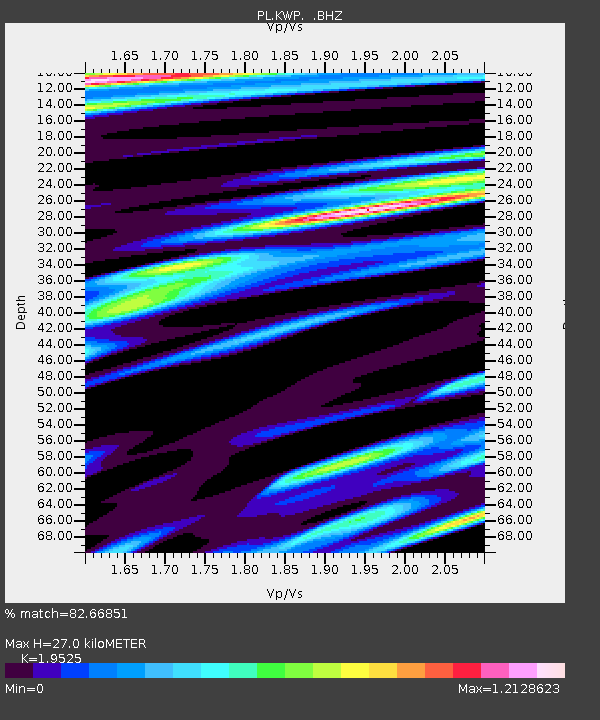
| Estimated Moho Depth: |
27.0 km |
| Estimated Crust Vp/Vs: |
1.95 |
| Assumed Crust Vp: |
6.53 km/s |
| Estimated Crust Vs: |
3.345 km/s |
| Estimated Crust Poisson's Ratio: |
0.32 |
|
| Radial Match: |
82.66851 % |
| Radial Bump: |
400 |
| Transverse Match: |
75.91214 % |
| Transverse Bump: |
400 |
| SOD ConfigId: |
346946 |
| Insert Time: |
2011-07-14 08:07:38.481 +0000 |
| GWidth: |
2.5 |
| Max Bumps: |
400 |
| Tol: |
0.001 |
|

Signal To Noise
| Channel | StoN | STA | LTA |
| PL:KWP: :BHZ:20110124T02:52:00.676006Z | 9.873153 | 2.0993633E-5 | 2.1263352E-6 |
| PL:KWP: :BHN:20110124T02:52:00.667003Z | 3.286942 | 8.901416E-6 | 2.7081146E-6 |
| PL:KWP: :BHE:20110124T02:52:00.667003Z | 2.1293283 | 9.007301E-6 | 4.2301135E-6 |
| Arrivals |
| Ps | 4.2 SECOND |
| PpPs | 11 SECOND |
| PsPs/PpSs | 16 SECOND |


