You are here: Home > Network List > US - United States National Seismic Network Stations List
> Station AMTX Amarillo, Texas, USA > Earthquake Result Viewer
AMTX Amarillo, Texas, USA - Earthquake Result Viewer
*The percent match for this event was below the threshold and hence no stack was calculated.
| Earthquake location: |
Northern Mid-Atlantic Ridge |
| Earthquake latitude/longitude: |
26.3/-44.4 |
| Earthquake time(UTC): |
2014/01/18 (018) 22:19:28 GMT |
| Earthquake Depth: |
11 km |
| Earthquake Magnitude: |
5.4 MW |
| Earthquake Catalog/Contributor: |
ISC/ISC |
|
| Network: |
US United States National Seismic Network |
| Station: |
AMTX Amarillo, Texas, USA |
| Lat/Lon: |
34.53 N/101.41 W |
| Elevation: |
1010 m |
|
| Distance: |
49.3 deg |
| Az: |
293.977 deg |
| Baz: |
83.304 deg |
| Ray Param: |
$rayparam |
*The percent match for this event was below the threshold and hence was not used in the summary stack. |
|
| Radial Match: |
67.1969 % |
| Radial Bump: |
400 |
| Transverse Match: |
46.622932 % |
| Transverse Bump: |
400 |
| SOD ConfigId: |
3390531 |
| Insert Time: |
2019-04-10 01:05:58.323 +0000 |
| GWidth: |
2.5 |
| Max Bumps: |
400 |
| Tol: |
0.001 |
|
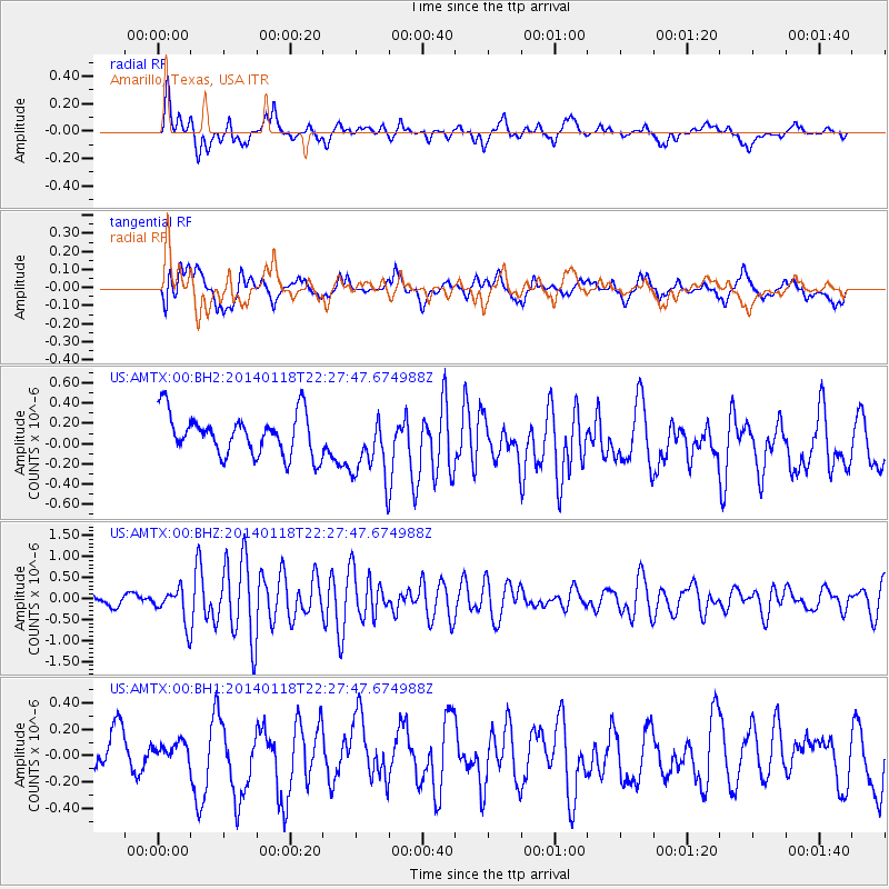
Signal To Noise
| Channel | StoN | STA | LTA |
| US:AMTX:00:BHZ:20140118T22:27:47.674988Z | 2.6751812 | 3.9393697E-7 | 1.4725617E-7 |
| US:AMTX:00:BH1:20140118T22:27:47.674988Z | 0.444559 | 8.129852E-8 | 1.8287453E-7 |
| US:AMTX:00:BH2:20140118T22:27:47.674988Z | 1.5819932 | 3.0379863E-7 | 1.9203534E-7 |
| Arrivals |
| Ps | |
| PpPs | |
| PsPs/PpSs | |


