You are here: Home > Network List > CI - Caltech Regional Seismic Network Stations List
> Station MPM Manuel Prospect Mine, California, USA > Earthquake Result Viewer
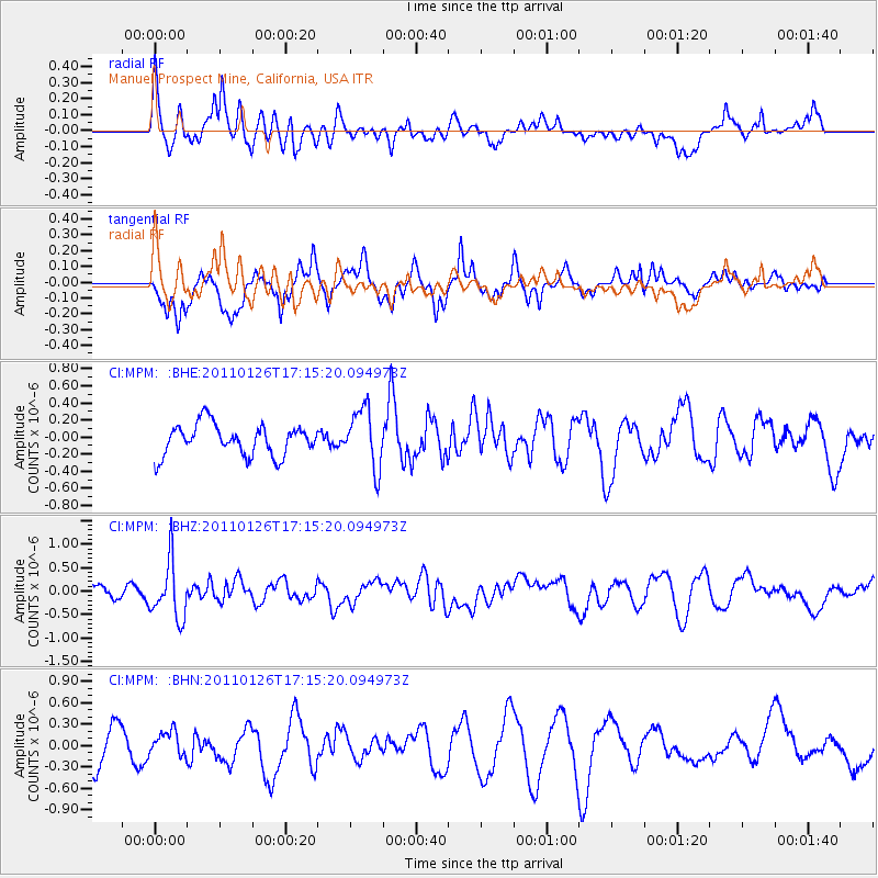
MPM Manuel Prospect Mine, California, USA - Earthquake Result Viewer
*The percent match for this event was below the threshold and hence no stack was calculated.
| Earthquake location: |
Santa Cruz Islands |
| Earthquake latitude/longitude: |
-11.0/166.3 |
| Earthquake time(UTC): |
2011/01/26 (026) 17:03:30 GMT |
| Earthquake Depth: |
148 km |
| Earthquake Magnitude: |
5.8 MB, 5.7 MW |
| Earthquake Catalog/Contributor: |
WHDF/NEIC |
|
| Network: |
CI Caltech Regional Seismic Network |
| Station: |
MPM Manuel Prospect Mine, California, USA |
| Lat/Lon: |
36.06 N/117.49 W |
| Elevation: |
185 m |
|
| Distance: |
85.5 deg |
| Az: |
52.126 deg |
| Baz: |
253.031 deg |
| Ray Param: |
$rayparam |
*The percent match for this event was below the threshold and hence was not used in the summary stack. |
|
| Radial Match: |
59.581776 % |
| Radial Bump: |
400 |
| Transverse Match: |
39.54623 % |
| Transverse Bump: |
392 |
| SOD ConfigId: |
346946 |
| Insert Time: |
2011-07-14 08:32:26.796 +0000 |
| GWidth: |
2.5 |
| Max Bumps: |
400 |
| Tol: |
0.001 |
|
Signal To Noise
| Channel | StoN | STA | LTA |
| CI:MPM: :BHZ:20110126T17:15:20.094973Z | 2.8178806 | 6.010016E-7 | 2.1328142E-7 |
| CI:MPM: :BHN:20110126T17:15:20.094973Z | 0.6432004 | 1.5723623E-7 | 2.4445916E-7 |
| CI:MPM: :BHE:20110126T17:15:20.094973Z | 1.9250385 | 3.4678877E-7 | 1.801464E-7 |
| Arrivals |
| Ps | |
| PpPs | |
| PsPs/PpSs | |


