You are here: Home > Network List > CI - Caltech Regional Seismic Network Stations List
> Station MPP McPhearson Peak > Earthquake Result Viewer
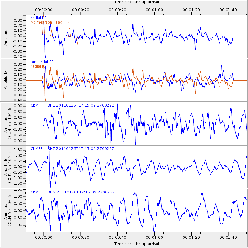
MPP McPhearson Peak - Earthquake Result Viewer
*The percent match for this event was below the threshold and hence no stack was calculated.
| Earthquake location: |
Santa Cruz Islands |
| Earthquake latitude/longitude: |
-11.0/166.3 |
| Earthquake time(UTC): |
2011/01/26 (026) 17:03:30 GMT |
| Earthquake Depth: |
148 km |
| Earthquake Magnitude: |
5.8 MB, 5.7 MW |
| Earthquake Catalog/Contributor: |
WHDF/NEIC |
|
| Network: |
CI Caltech Regional Seismic Network |
| Station: |
MPP McPhearson Peak |
| Lat/Lon: |
34.89 N/119.81 W |
| Elevation: |
1739 m |
|
| Distance: |
83.3 deg |
| Az: |
52.667 deg |
| Baz: |
251.74 deg |
| Ray Param: |
$rayparam |
*The percent match for this event was below the threshold and hence was not used in the summary stack. |
|
| Radial Match: |
73.036194 % |
| Radial Bump: |
400 |
| Transverse Match: |
67.55328 % |
| Transverse Bump: |
400 |
| SOD ConfigId: |
346946 |
| Insert Time: |
2011-07-14 08:33:39.076 +0000 |
| GWidth: |
2.5 |
| Max Bumps: |
400 |
| Tol: |
0.001 |
|
Signal To Noise
| Channel | StoN | STA | LTA |
| CI:MPP: :BHZ:20110126T17:15:09.270022Z | 2.1966188 | 8.880764E-7 | 4.0429245E-7 |
| CI:MPP: :BHN:20110126T17:15:09.270022Z | 1.5664264 | 5.547001E-7 | 3.5411819E-7 |
| CI:MPP: :BHE:20110126T17:15:09.270022Z | 1.0531468 | 3.7105767E-7 | 3.523323E-7 |
| Arrivals |
| Ps | |
| PpPs | |
| PsPs/PpSs | |


