You are here: Home > Network List > XG92 - Rocky Mountain Front Stations List
> Station LMN Limon, CO > Earthquake Result Viewer
LMN Limon, CO - Earthquake Result Viewer
| Earthquake location: |
Gulf Of Alaska |
| Earthquake latitude/longitude: |
57.6/-143.0 |
| Earthquake time(UTC): |
1992/08/07 (220) 18:19:19 GMT |
| Earthquake Depth: |
10 km |
| Earthquake Magnitude: |
6.3 MB, 6.5 MS, 6.5 ML |
| Earthquake Catalog/Contributor: |
WHDF/NEIC |
|
| Network: |
XG Rocky Mountain Front |
| Station: |
LMN Limon, CO |
| Lat/Lon: |
39.42 N/103.62 W |
| Elevation: |
1665 m |
|
| Distance: |
31.2 deg |
| Az: |
108.421 deg |
| Baz: |
318.75 deg |
| Ray Param: |
0.07912368 |
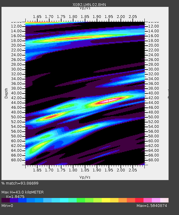
| Estimated Moho Depth: |
43.0 km |
| Estimated Crust Vp/Vs: |
1.95 |
| Assumed Crust Vp: |
6.242 km/s |
| Estimated Crust Vs: |
3.205 km/s |
| Estimated Crust Poisson's Ratio: |
0.32 |
|
| Radial Match: |
93.86699 % |
| Radial Bump: |
253 |
| Transverse Match: |
85.44315 % |
| Transverse Bump: |
387 |
| SOD ConfigId: |
3286 |
| Insert Time: |
2010-02-25 20:09:51.822 +0000 |
| GWidth: |
2.5 |
| Max Bumps: |
400 |
| Tol: |
0.001 |
|

Signal To Noise
| Channel | StoN | STA | LTA |
| XG:LMN:02:BHN:19920807T18:25:08.19801Z | 10.241634 | 0.0020839467 | 2.0347795E-4 |
| XG:LMN:02:BHE:19920807T18:25:08.19801Z | 9.218766 | 0.001757492 | 1.9064285E-4 |
| XG:LMN:02:BHZ:19920807T18:25:08.19801Z | 56.057453 | 0.008721127 | 1.5557482E-4 |
| Arrivals |
| Ps | 7.0 SECOND |
| PpPs | 19 SECOND |
| PsPs/PpSs | 26 SECOND |


