You are here: Home > Network List > TA - USArray Transportable Network (new EarthScope stations) Stations List
> Station L04D Klamath Falls, OR, USA > Earthquake Result Viewer
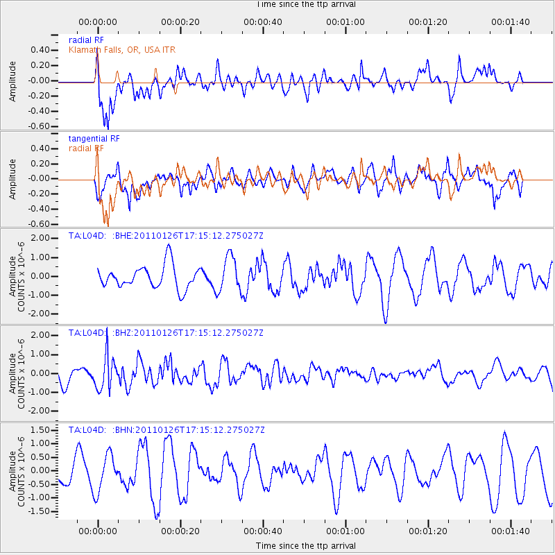
L04D Klamath Falls, OR, USA - Earthquake Result Viewer
*The percent match for this event was below the threshold and hence no stack was calculated.
| Earthquake location: |
Santa Cruz Islands |
| Earthquake latitude/longitude: |
-11.0/166.3 |
| Earthquake time(UTC): |
2011/01/26 (026) 17:03:30 GMT |
| Earthquake Depth: |
148 km |
| Earthquake Magnitude: |
5.8 MB, 5.7 MW |
| Earthquake Catalog/Contributor: |
WHDF/NEIC |
|
| Network: |
TA USArray Transportable Network (new EarthScope stations) |
| Station: |
L04D Klamath Falls, OR, USA |
| Lat/Lon: |
42.22 N/122.30 W |
| Elevation: |
1437 m |
|
| Distance: |
83.9 deg |
| Az: |
45.07 deg |
| Baz: |
249.347 deg |
| Ray Param: |
$rayparam |
*The percent match for this event was below the threshold and hence was not used in the summary stack. |
|
| Radial Match: |
68.3586 % |
| Radial Bump: |
400 |
| Transverse Match: |
75.39671 % |
| Transverse Bump: |
400 |
| SOD ConfigId: |
346946 |
| Insert Time: |
2011-07-14 08:42:43.615 +0000 |
| GWidth: |
2.5 |
| Max Bumps: |
400 |
| Tol: |
0.001 |
|
Signal To Noise
| Channel | StoN | STA | LTA |
| TA:L04D: :BHZ:20110126T17:15:12.275027Z | 1.7516462 | 8.9790484E-7 | 5.126063E-7 |
| TA:L04D: :BHN:20110126T17:15:12.275027Z | 0.85418963 | 6.8685773E-7 | 8.041045E-7 |
| TA:L04D: :BHE:20110126T17:15:12.275027Z | 1.5601501 | 9.453605E-7 | 6.05942E-7 |
| Arrivals |
| Ps | |
| PpPs | |
| PsPs/PpSs | |


