You are here: Home > Network List > TA - USArray Transportable Network (new EarthScope stations) Stations List
> Station O03D Paynes Creek, CA, USA > Earthquake Result Viewer
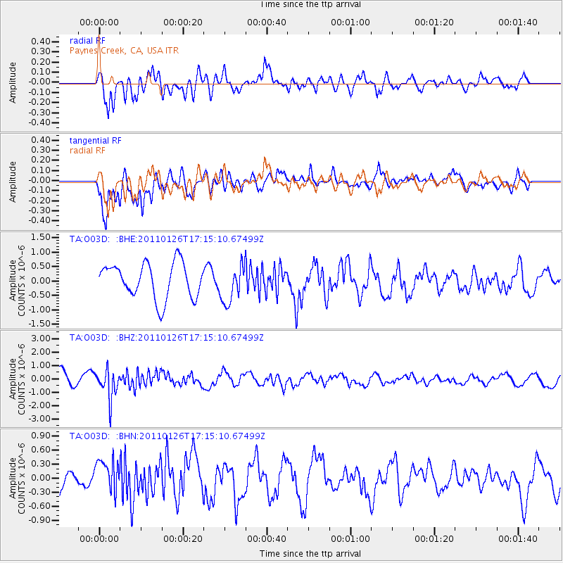
O03D Paynes Creek, CA, USA - Earthquake Result Viewer
*The percent match for this event was below the threshold and hence no stack was calculated.
| Earthquake location: |
Santa Cruz Islands |
| Earthquake latitude/longitude: |
-11.0/166.3 |
| Earthquake time(UTC): |
2011/01/26 (026) 17:03:30 GMT |
| Earthquake Depth: |
148 km |
| Earthquake Magnitude: |
5.8 MB, 5.7 MW |
| Earthquake Catalog/Contributor: |
WHDF/NEIC |
|
| Network: |
TA USArray Transportable Network (new EarthScope stations) |
| Station: |
O03D Paynes Creek, CA, USA |
| Lat/Lon: |
40.29 N/121.80 W |
| Elevation: |
968 m |
|
| Distance: |
83.6 deg |
| Az: |
47.014 deg |
| Baz: |
249.889 deg |
| Ray Param: |
$rayparam |
*The percent match for this event was below the threshold and hence was not used in the summary stack. |
|
| Radial Match: |
56.32745 % |
| Radial Bump: |
400 |
| Transverse Match: |
83.12023 % |
| Transverse Bump: |
400 |
| SOD ConfigId: |
346946 |
| Insert Time: |
2011-07-14 08:42:53.443 +0000 |
| GWidth: |
2.5 |
| Max Bumps: |
400 |
| Tol: |
0.001 |
|
Signal To Noise
| Channel | StoN | STA | LTA |
| TA:O03D: :BHZ:20110126T17:15:10.67499Z | 1.9851207 | 1.0927693E-6 | 5.5048E-7 |
| TA:O03D: :BHN:20110126T17:15:10.67499Z | 1.2363657 | 3.7754955E-7 | 3.0537046E-7 |
| TA:O03D: :BHE:20110126T17:15:10.67499Z | 1.0944681 | 6.6632936E-7 | 6.088157E-7 |
| Arrivals |
| Ps | |
| PpPs | |
| PsPs/PpSs | |


