You are here: Home > Network List > KN - Kyrgyz Seismic Telemetry Network Stations List
> Station TKM2 - > Earthquake Result Viewer
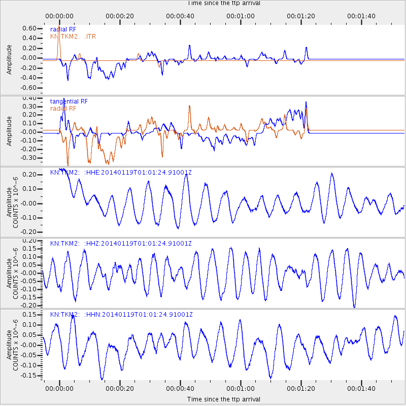
TKM2 - - Earthquake Result Viewer
*The percent match for this event was below the threshold and hence no stack was calculated.
| Earthquake location: |
Kuril Islands |
| Earthquake latitude/longitude: |
49.1/156.4 |
| Earthquake time(UTC): |
2014/01/19 (019) 00:52:35 GMT |
| Earthquake Depth: |
34 km |
| Earthquake Magnitude: |
4.9 MW |
| Earthquake Catalog/Contributor: |
ISC/ISC |
|
| Network: |
KN Kyrgyz Seismic Telemetry Network |
| Station: |
TKM2 - |
| Lat/Lon: |
42.92 N/75.60 E |
| Elevation: |
2020 m |
|
| Distance: |
53.9 deg |
| Az: |
296.233 deg |
| Baz: |
53.417 deg |
| Ray Param: |
$rayparam |
*The percent match for this event was below the threshold and hence was not used in the summary stack. |
|
| Radial Match: |
43.11059 % |
| Radial Bump: |
400 |
| Transverse Match: |
40.518482 % |
| Transverse Bump: |
400 |
| SOD ConfigId: |
3390531 |
| Insert Time: |
2019-04-10 01:11:27.109 +0000 |
| GWidth: |
2.5 |
| Max Bumps: |
400 |
| Tol: |
0.001 |
|
Signal To Noise
| Channel | StoN | STA | LTA |
| KN:TKM2: :HHZ:20140119T01:01:24.91001Z | 1.4453162 | 8.0863956E-8 | 5.594897E-8 |
| KN:TKM2: :HHN:20140119T01:01:24.91001Z | 1.818358 | 8.7969894E-8 | 4.8378755E-8 |
| KN:TKM2: :HHE:20140119T01:01:24.91001Z | 1.1995459 | 1.2037192E-7 | 1.0034791E-7 |
| Arrivals |
| Ps | |
| PpPs | |
| PsPs/PpSs | |


