You are here: Home > Network List > CI - Caltech Regional Seismic Network Stations List
> Station LRL Laurel Mtn Radio Fac, Ridgecrest, CA, USA > Earthquake Result Viewer
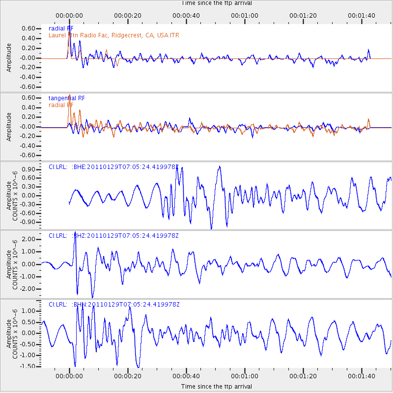
LRL Laurel Mtn Radio Fac, Ridgecrest, CA, USA - Earthquake Result Viewer
*The percent match for this event was below the threshold and hence no stack was calculated.
| Earthquake location: |
Jan Mayen Island Region |
| Earthquake latitude/longitude: |
70.9/-6.7 |
| Earthquake time(UTC): |
2011/01/29 (029) 06:55:26 GMT |
| Earthquake Depth: |
6.0 km |
| Earthquake Magnitude: |
6.1 MB, 6.1 MS, 6.2 MW, 6.2 MW |
| Earthquake Catalog/Contributor: |
WHDF/NEIC |
|
| Network: |
CI Caltech Regional Seismic Network |
| Station: |
LRL Laurel Mtn Radio Fac, Ridgecrest, CA, USA |
| Lat/Lon: |
35.48 N/117.68 W |
| Elevation: |
1340 m |
|
| Distance: |
63.3 deg |
| Az: |
301.458 deg |
| Baz: |
20.086 deg |
| Ray Param: |
$rayparam |
*The percent match for this event was below the threshold and hence was not used in the summary stack. |
|
| Radial Match: |
69.093834 % |
| Radial Bump: |
400 |
| Transverse Match: |
62.5664 % |
| Transverse Bump: |
396 |
| SOD ConfigId: |
350818 |
| Insert Time: |
2011-07-20 07:12:58.039 +0000 |
| GWidth: |
2.5 |
| Max Bumps: |
400 |
| Tol: |
0.001 |
|
Signal To Noise
| Channel | StoN | STA | LTA |
| CI:LRL: :BHZ:20110129T07:05:24.419978Z | 5.557649 | 1.057457E-6 | 1.9027055E-7 |
| CI:LRL: :BHN:20110129T07:05:24.419978Z | 2.1556904 | 7.377917E-7 | 3.422531E-7 |
| CI:LRL: :BHE:20110129T07:05:24.419978Z | 2.2701914 | 3.980389E-7 | 1.7533274E-7 |
| Arrivals |
| Ps | |
| PpPs | |
| PsPs/PpSs | |


