You are here: Home > Network List > CI - Caltech Regional Seismic Network Stations List
> Station LGU LGU, Camarillo, CA, USA > Earthquake Result Viewer
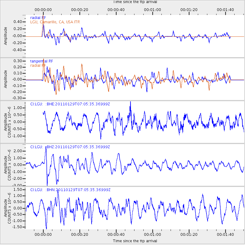
LGU LGU, Camarillo, CA, USA - Earthquake Result Viewer
*The percent match for this event was below the threshold and hence no stack was calculated.
| Earthquake location: |
Jan Mayen Island Region |
| Earthquake latitude/longitude: |
70.9/-6.7 |
| Earthquake time(UTC): |
2011/01/29 (029) 06:55:26 GMT |
| Earthquake Depth: |
6.0 km |
| Earthquake Magnitude: |
6.1 MB, 6.1 MS, 6.2 MW, 6.2 MW |
| Earthquake Catalog/Contributor: |
WHDF/NEIC |
|
| Network: |
CI Caltech Regional Seismic Network |
| Station: |
LGU LGU, Camarillo, CA, USA |
| Lat/Lon: |
34.11 N/119.07 W |
| Elevation: |
416 m |
|
| Distance: |
65.0 deg |
| Az: |
302.133 deg |
| Baz: |
19.594 deg |
| Ray Param: |
$rayparam |
*The percent match for this event was below the threshold and hence was not used in the summary stack. |
|
| Radial Match: |
63.770714 % |
| Radial Bump: |
400 |
| Transverse Match: |
71.281265 % |
| Transverse Bump: |
400 |
| SOD ConfigId: |
350818 |
| Insert Time: |
2011-07-20 07:18:57.810 +0000 |
| GWidth: |
2.5 |
| Max Bumps: |
400 |
| Tol: |
0.001 |
|
Signal To Noise
| Channel | StoN | STA | LTA |
| CI:LGU: :BHZ:20110129T07:05:35.36999Z | 3.7323277 | 1.3215431E-6 | 3.5408016E-7 |
| CI:LGU: :BHN:20110129T07:05:35.36999Z | 1.6460354 | 6.0756656E-7 | 3.6910905E-7 |
| CI:LGU: :BHE:20110129T07:05:35.36999Z | 1.2581961 | 5.070188E-7 | 4.0297277E-7 |
| Arrivals |
| Ps | |
| PpPs | |
| PsPs/PpSs | |


