You are here: Home > Network List > CI - Caltech Regional Seismic Network Stations List
> Station SMM Simmler, CA, USA > Earthquake Result Viewer
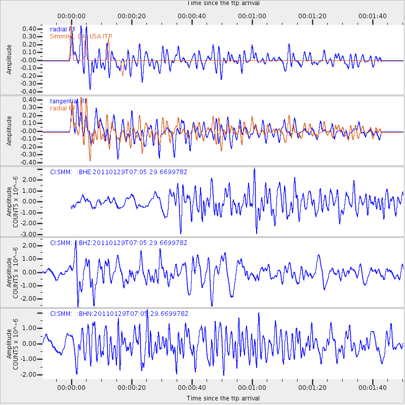
SMM Simmler, CA, USA - Earthquake Result Viewer
*The percent match for this event was below the threshold and hence no stack was calculated.
| Earthquake location: |
Jan Mayen Island Region |
| Earthquake latitude/longitude: |
70.9/-6.7 |
| Earthquake time(UTC): |
2011/01/29 (029) 06:55:26 GMT |
| Earthquake Depth: |
6.0 km |
| Earthquake Magnitude: |
6.1 MB, 6.1 MS, 6.2 MW, 6.2 MW |
| Earthquake Catalog/Contributor: |
WHDF/NEIC |
|
| Network: |
CI Caltech Regional Seismic Network |
| Station: |
SMM Simmler, CA, USA |
| Lat/Lon: |
35.31 N/120.00 W |
| Elevation: |
599 m |
|
| Distance: |
64.1 deg |
| Az: |
303.379 deg |
| Baz: |
19.604 deg |
| Ray Param: |
$rayparam |
*The percent match for this event was below the threshold and hence was not used in the summary stack. |
|
| Radial Match: |
50.76167 % |
| Radial Bump: |
400 |
| Transverse Match: |
58.329144 % |
| Transverse Bump: |
400 |
| SOD ConfigId: |
350818 |
| Insert Time: |
2011-07-20 07:19:45.575 +0000 |
| GWidth: |
2.5 |
| Max Bumps: |
400 |
| Tol: |
0.001 |
|
Signal To Noise
| Channel | StoN | STA | LTA |
| CI:SMM: :BHZ:20110129T07:05:29.669978Z | 5.9450207 | 1.1699694E-6 | 1.967982E-7 |
| CI:SMM: :BHN:20110129T07:05:29.669978Z | 1.8832707 | 8.220722E-7 | 4.36513E-7 |
| CI:SMM: :BHE:20110129T07:05:29.669978Z | 2.3711848 | 8.35444E-7 | 3.5233188E-7 |
| Arrivals |
| Ps | |
| PpPs | |
| PsPs/PpSs | |


