You are here: Home > Network List > XG92 - Rocky Mountain Front Stations List
> Station LMN Limon, CO > Earthquake Result Viewer
LMN Limon, CO - Earthquake Result Viewer
| Earthquake location: |
Near East Coast Of Kamchatka |
| Earthquake latitude/longitude: |
51.2/157.7 |
| Earthquake time(UTC): |
1992/07/13 (195) 15:34:05 GMT |
| Earthquake Depth: |
53 km |
| Earthquake Magnitude: |
5.7 MB |
| Earthquake Catalog/Contributor: |
WHDF/NEIC |
|
| Network: |
XG Rocky Mountain Front |
| Station: |
LMN Limon, CO |
| Lat/Lon: |
39.42 N/103.62 W |
| Elevation: |
1665 m |
|
| Distance: |
65.3 deg |
| Az: |
57.419 deg |
| Baz: |
316.767 deg |
| Ray Param: |
0.058228735 |
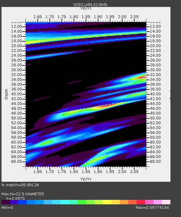
| Estimated Moho Depth: |
32.5 km |
| Estimated Crust Vp/Vs: |
2.10 |
| Assumed Crust Vp: |
6.242 km/s |
| Estimated Crust Vs: |
2.976 km/s |
| Estimated Crust Poisson's Ratio: |
0.35 |
|
| Radial Match: |
89.89126 % |
| Radial Bump: |
400 |
| Transverse Match: |
84.83295 % |
| Transverse Bump: |
400 |
| SOD ConfigId: |
3286 |
| Insert Time: |
2010-02-25 20:09:54.333 +0000 |
| GWidth: |
2.5 |
| Max Bumps: |
400 |
| Tol: |
0.001 |
|

Signal To Noise
| Channel | StoN | STA | LTA |
| XG:LMN:02:BHN:19920713T15:44:11.330017Z | 1.3701986 | 2.0549573E-4 | 1.4997514E-4 |
| XG:LMN:02:BHE:19920713T15:44:11.330017Z | 0.6930239 | 1.1569448E-4 | 1.6694152E-4 |
| XG:LMN:02:BHZ:19920713T15:44:11.330017Z | 8.265766 | 9.709864E-4 | 1.1747082E-4 |
| Arrivals |
| Ps | 5.9 SECOND |
| PpPs | 16 SECOND |
| PsPs/PpSs | 22 SECOND |


