You are here: Home > Network List > IU - Global Seismograph Network (GSN - IRIS/USGS) Stations List
> Station HKT Hockley, Texas > Earthquake Result Viewer
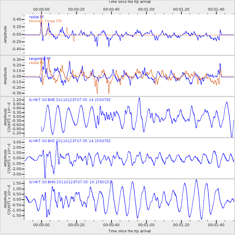
HKT Hockley, Texas - Earthquake Result Viewer
*The percent match for this event was below the threshold and hence no stack was calculated.
| Earthquake location: |
Jan Mayen Island Region |
| Earthquake latitude/longitude: |
70.9/-6.7 |
| Earthquake time(UTC): |
2011/01/29 (029) 06:55:26 GMT |
| Earthquake Depth: |
6.0 km |
| Earthquake Magnitude: |
6.1 MB, 6.1 MS, 6.2 MW, 6.2 MW |
| Earthquake Catalog/Contributor: |
WHDF/NEIC |
|
| Network: |
IU Global Seismograph Network (GSN - IRIS/USGS) |
| Station: |
HKT Hockley, Texas |
| Lat/Lon: |
29.96 N/95.84 W |
| Elevation: |
-413.0 m |
|
| Distance: |
61.7 deg |
| Az: |
279.888 deg |
| Baz: |
21.902 deg |
| Ray Param: |
$rayparam |
*The percent match for this event was below the threshold and hence was not used in the summary stack. |
|
| Radial Match: |
46.753567 % |
| Radial Bump: |
355 |
| Transverse Match: |
60.980198 % |
| Transverse Bump: |
367 |
| SOD ConfigId: |
350818 |
| Insert Time: |
2011-07-20 07:33:26.631 +0000 |
| GWidth: |
2.5 |
| Max Bumps: |
400 |
| Tol: |
0.001 |
|
Signal To Noise
| Channel | StoN | STA | LTA |
| IU:HKT:00:BHZ:20110129T07:05:14.156978Z | 3.5012274 | 1.4116564E-6 | 4.03189E-7 |
| IU:HKT:00:BHN:20110129T07:05:14.158015Z | 2.6301768 | 7.3863094E-7 | 2.808294E-7 |
| IU:HKT:00:BHE:20110129T07:05:14.156978Z | 0.76880455 | 4.94403E-7 | 6.430803E-7 |
| Arrivals |
| Ps | |
| PpPs | |
| PsPs/PpSs | |


