You are here: Home > Network List > IW - Intermountain West Stations List
> Station MOOW Moose Ponds, Wyoming, USA > Earthquake Result Viewer
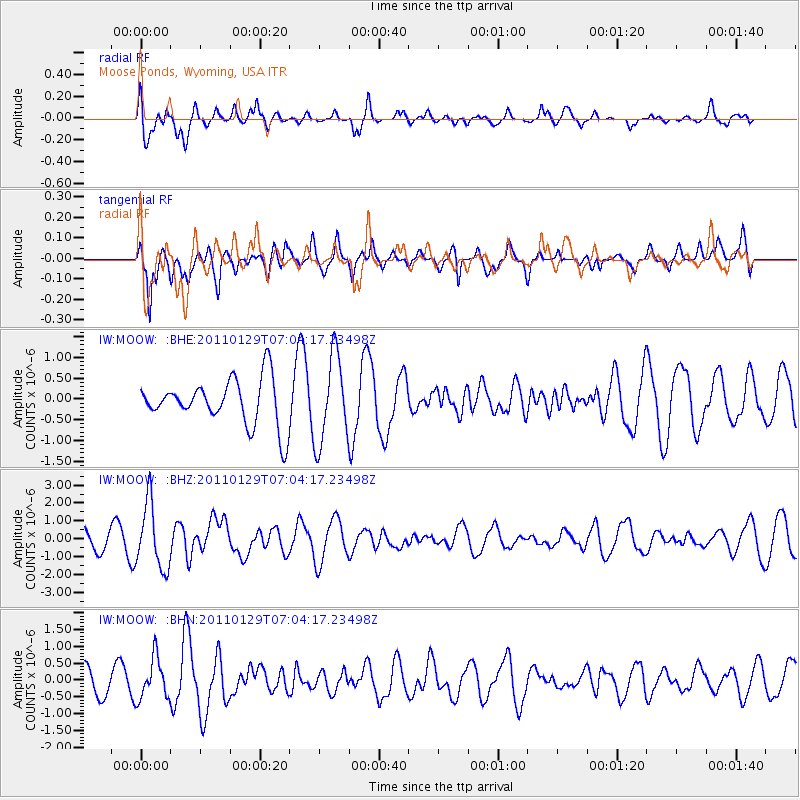
MOOW Moose Ponds, Wyoming, USA - Earthquake Result Viewer
*The percent match for this event was below the threshold and hence no stack was calculated.
| Earthquake location: |
Jan Mayen Island Region |
| Earthquake latitude/longitude: |
70.9/-6.7 |
| Earthquake time(UTC): |
2011/01/29 (029) 06:55:26 GMT |
| Earthquake Depth: |
6.0 km |
| Earthquake Magnitude: |
6.1 MB, 6.1 MS, 6.2 MW, 6.2 MW |
| Earthquake Catalog/Contributor: |
WHDF/NEIC |
|
| Network: |
IW Intermountain West |
| Station: |
MOOW Moose Ponds, Wyoming, USA |
| Lat/Lon: |
43.75 N/110.74 W |
| Elevation: |
2128 m |
|
| Distance: |
53.6 deg |
| Az: |
299.193 deg |
| Baz: |
23.317 deg |
| Ray Param: |
$rayparam |
*The percent match for this event was below the threshold and hence was not used in the summary stack. |
|
| Radial Match: |
74.23292 % |
| Radial Bump: |
400 |
| Transverse Match: |
82.80913 % |
| Transverse Bump: |
400 |
| SOD ConfigId: |
350818 |
| Insert Time: |
2011-07-20 07:35:31.523 +0000 |
| GWidth: |
2.5 |
| Max Bumps: |
400 |
| Tol: |
0.001 |
|
Signal To Noise
| Channel | StoN | STA | LTA |
| IW:MOOW: :BHZ:20110129T07:04:17.23498Z | 4.8023148 | 1.8367937E-6 | 3.8248092E-7 |
| IW:MOOW: :BHN:20110129T07:04:17.23498Z | 1.5218071 | 6.069567E-7 | 3.9883943E-7 |
| IW:MOOW: :BHE:20110129T07:04:17.23498Z | 1.9142083 | 1.0508659E-6 | 5.48982E-7 |
| Arrivals |
| Ps | |
| PpPs | |
| PsPs/PpSs | |


