You are here: Home > Network List > TA - USArray Transportable Network (new EarthScope stations) Stations List
> Station S56A Natural Bridge, VA, USA > Earthquake Result Viewer
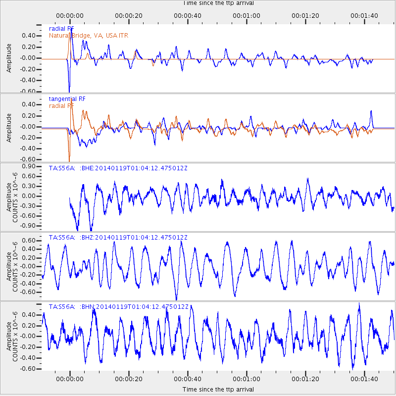
S56A Natural Bridge, VA, USA - Earthquake Result Viewer
*The percent match for this event was below the threshold and hence no stack was calculated.
| Earthquake location: |
Kuril Islands |
| Earthquake latitude/longitude: |
49.1/156.4 |
| Earthquake time(UTC): |
2014/01/19 (019) 00:52:35 GMT |
| Earthquake Depth: |
34 km |
| Earthquake Magnitude: |
4.9 MW |
| Earthquake Catalog/Contributor: |
ISC/ISC |
|
| Network: |
TA USArray Transportable Network (new EarthScope stations) |
| Station: |
S56A Natural Bridge, VA, USA |
| Lat/Lon: |
37.68 N/79.57 W |
| Elevation: |
449 m |
|
| Distance: |
80.4 deg |
| Az: |
41.792 deg |
| Baz: |
326.474 deg |
| Ray Param: |
$rayparam |
*The percent match for this event was below the threshold and hence was not used in the summary stack. |
|
| Radial Match: |
72.799675 % |
| Radial Bump: |
400 |
| Transverse Match: |
50.729465 % |
| Transverse Bump: |
400 |
| SOD ConfigId: |
3390531 |
| Insert Time: |
2019-04-10 01:14:23.225 +0000 |
| GWidth: |
2.5 |
| Max Bumps: |
400 |
| Tol: |
0.001 |
|
Signal To Noise
| Channel | StoN | STA | LTA |
| TA:S56A: :BHZ:20140119T01:04:12.475012Z | 0.39182281 | 1.40043E-7 | 3.574141E-7 |
| TA:S56A: :BHN:20140119T01:04:12.475012Z | 0.45391527 | 1.1905571E-7 | 2.6228622E-7 |
| TA:S56A: :BHE:20140119T01:04:12.475012Z | 0.7235181 | 2.5183925E-7 | 3.4807596E-7 |
| Arrivals |
| Ps | |
| PpPs | |
| PsPs/PpSs | |


