You are here: Home > Network List > TA - USArray Transportable Network (new EarthScope stations) Stations List
> Station S60A Water View, VA, USA > Earthquake Result Viewer
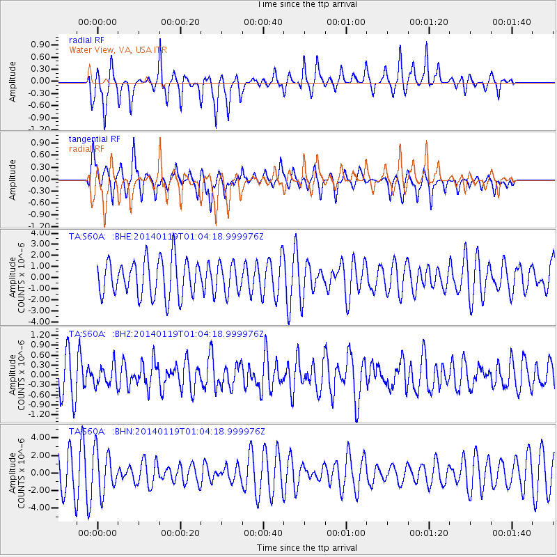
S60A Water View, VA, USA - Earthquake Result Viewer
*The percent match for this event was below the threshold and hence no stack was calculated.
| Earthquake location: |
Kuril Islands |
| Earthquake latitude/longitude: |
49.1/156.4 |
| Earthquake time(UTC): |
2014/01/19 (019) 00:52:35 GMT |
| Earthquake Depth: |
34 km |
| Earthquake Magnitude: |
4.9 MW |
| Earthquake Catalog/Contributor: |
ISC/ISC |
|
| Network: |
TA USArray Transportable Network (new EarthScope stations) |
| Station: |
S60A Water View, VA, USA |
| Lat/Lon: |
37.42 N/76.39 W |
| Elevation: |
36 m |
|
| Distance: |
82.0 deg |
| Az: |
39.783 deg |
| Baz: |
328.094 deg |
| Ray Param: |
$rayparam |
*The percent match for this event was below the threshold and hence was not used in the summary stack. |
|
| Radial Match: |
65.89152 % |
| Radial Bump: |
255 |
| Transverse Match: |
67.526505 % |
| Transverse Bump: |
310 |
| SOD ConfigId: |
3390531 |
| Insert Time: |
2019-04-10 01:14:24.422 +0000 |
| GWidth: |
2.5 |
| Max Bumps: |
400 |
| Tol: |
0.001 |
|
Signal To Noise
| Channel | StoN | STA | LTA |
| TA:S60A: :BHZ:20140119T01:04:18.999976Z | 0.5560202 | 3.0965248E-7 | 5.569087E-7 |
| TA:S60A: :BHN:20140119T01:04:18.999976Z | 1.6087587 | 2.4484145E-6 | 1.5219277E-6 |
| TA:S60A: :BHE:20140119T01:04:18.999976Z | 0.78423136 | 1.2819454E-6 | 1.634652E-6 |
| Arrivals |
| Ps | |
| PpPs | |
| PsPs/PpSs | |


