You are here: Home > Network List > AZ - ANZA Regional Network Stations List
> Station HWB AZ.HWB > Earthquake Result Viewer
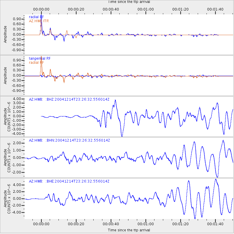
HWB AZ.HWB - Earthquake Result Viewer

| Earthquake location: |
Caribbean Sea |
| Earthquake latitude/longitude: |
19.0/-81.4 |
| Earthquake time(UTC): |
2004/12/14 (349) 23:20:13 GMT |
| Earthquake Depth: |
10 km |
| Earthquake Magnitude: |
6.2 MB, 6.7 MS, 6.8 MW, 6.8 MW |
| Earthquake Catalog/Contributor: |
WHDF/NEIC |
|
| Network: |
AZ ANZA Regional Network |
| Station: |
HWB AZ.HWB |
| Lat/Lon: |
33.03 N/116.96 W |
| Elevation: |
478 m |
|
| Distance: |
34.7 deg |
| Az: |
300.929 deg |
| Baz: |
104.899 deg |
| Ray Param: |
0.07760134 |
| Estimated Moho Depth: |
16.5 km |
| Estimated Crust Vp/Vs: |
1.60 |
| Assumed Crust Vp: |
6.264 km/s |
| Estimated Crust Vs: |
3.909 km/s |
| Estimated Crust Poisson's Ratio: |
0.18 |
|
| Radial Match: |
92.57699 % |
| Radial Bump: |
177 |
| Transverse Match: |
71.86269 % |
| Transverse Bump: |
400 |
| SOD ConfigId: |
2459 |
| Insert Time: |
2010-02-26 19:24:37.370 +0000 |
| GWidth: |
2.5 |
| Max Bumps: |
400 |
| Tol: |
0.001 |
|
Signal To Noise
| Channel | StoN | STA | LTA |
| AZ:HWB: :BHN:20041214T23:26:32.556014Z | 1.976077 | 1.7557119E-7 | 8.884836E-8 |
| AZ:HWB: :BHE:20041214T23:26:32.556014Z | 7.3866453 | 5.658165E-7 | 7.6599925E-8 |
| AZ:HWB: :BHZ:20041214T23:26:32.556014Z | 7.030229 | 9.2630916E-7 | 1.3176087E-7 |
| Arrivals |
| Ps | 1.7 SECOND |
| PpPs | 6.3 SECOND |
| PsPs/PpSs | 8.0 SECOND |


