You are here: Home > Network List > AZ - ANZA Regional Network Stations List
> Station HWB AZ.HWB > Earthquake Result Viewer
HWB AZ.HWB - Earthquake Result Viewer

| Earthquake location: |
Hokkaido, Japan Region |
| Earthquake latitude/longitude: |
42.9/145.2 |
| Earthquake time(UTC): |
2004/12/06 (341) 14:15:11 GMT |
| Earthquake Depth: |
35 km |
| Earthquake Magnitude: |
6.5 MB, 6.5 MS, 6.8 MW, 6.8 MW |
| Earthquake Catalog/Contributor: |
WHDF/NEIC |
|
| Network: |
AZ ANZA Regional Network |
| Station: |
HWB AZ.HWB |
| Lat/Lon: |
33.03 N/116.96 W |
| Elevation: |
478 m |
|
| Distance: |
73.5 deg |
| Az: |
60.231 deg |
| Baz: |
310.601 deg |
| Ray Param: |
0.052910045 |
| Estimated Moho Depth: |
33.0 km |
| Estimated Crust Vp/Vs: |
1.98 |
| Assumed Crust Vp: |
6.264 km/s |
| Estimated Crust Vs: |
3.159 km/s |
| Estimated Crust Poisson's Ratio: |
0.33 |
|
| Radial Match: |
83.99187 % |
| Radial Bump: |
400 |
| Transverse Match: |
60.000835 % |
| Transverse Bump: |
400 |
| SOD ConfigId: |
2459 |
| Insert Time: |
2010-02-26 19:24:38.222 +0000 |
| GWidth: |
2.5 |
| Max Bumps: |
400 |
| Tol: |
0.001 |
|
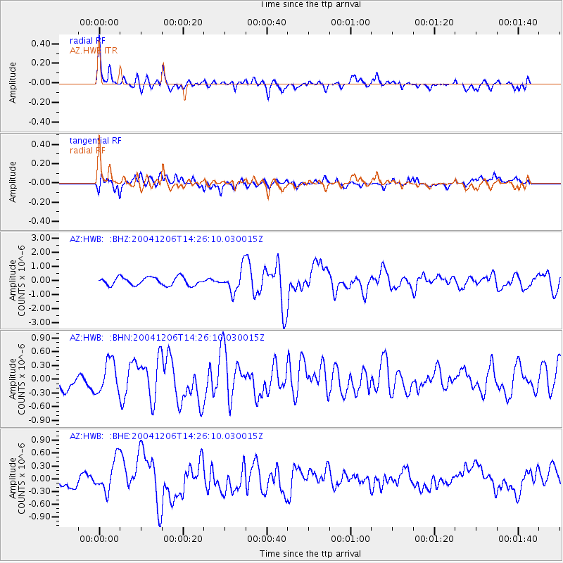
Signal To Noise
| Channel | StoN | STA | LTA |
| AZ:HWB: :BHN:20041206T14:26:10.030015Z | 2.031051 | 3.476456E-7 | 1.7116538E-7 |
| AZ:HWB: :BHE:20041206T14:26:10.030015Z | 2.4298253 | 4.0483698E-7 | 1.6661156E-7 |
| AZ:HWB: :BHZ:20041206T14:26:10.030015Z | 3.0250263 | 8.6304584E-7 | 2.8530192E-7 |
| Arrivals |
| Ps | 5.3 SECOND |
| PpPs | 15 SECOND |
| PsPs/PpSs | 21 SECOND |


