You are here: Home > Network List > TA - USArray Transportable Network (new EarthScope stations) Stations List
> Station MDND Maddock, ND, USA > Earthquake Result Viewer
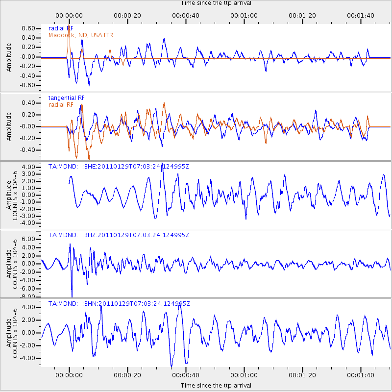
MDND Maddock, ND, USA - Earthquake Result Viewer
*The percent match for this event was below the threshold and hence no stack was calculated.
| Earthquake location: |
Jan Mayen Island Region |
| Earthquake latitude/longitude: |
70.9/-6.7 |
| Earthquake time(UTC): |
2011/01/29 (029) 06:55:26 GMT |
| Earthquake Depth: |
6.0 km |
| Earthquake Magnitude: |
6.1 MB, 6.1 MS, 6.2 MW, 6.2 MW |
| Earthquake Catalog/Contributor: |
WHDF/NEIC |
|
| Network: |
TA USArray Transportable Network (new EarthScope stations) |
| Station: |
MDND Maddock, ND, USA |
| Lat/Lon: |
47.85 N/99.60 W |
| Elevation: |
479 m |
|
| Distance: |
46.6 deg |
| Az: |
292.258 deg |
| Baz: |
26.839 deg |
| Ray Param: |
$rayparam |
*The percent match for this event was below the threshold and hence was not used in the summary stack. |
|
| Radial Match: |
63.368008 % |
| Radial Bump: |
357 |
| Transverse Match: |
64.76893 % |
| Transverse Bump: |
388 |
| SOD ConfigId: |
350818 |
| Insert Time: |
2011-07-20 07:55:17.280 +0000 |
| GWidth: |
2.5 |
| Max Bumps: |
400 |
| Tol: |
0.001 |
|
Signal To Noise
| Channel | StoN | STA | LTA |
| TA:MDND: :BHZ:20110129T07:03:24.124995Z | 3.762728 | 2.7593765E-6 | 7.333446E-7 |
| TA:MDND: :BHN:20110129T07:03:24.124995Z | 0.88202137 | 1.2014555E-6 | 1.3621614E-6 |
| TA:MDND: :BHE:20110129T07:03:24.124995Z | 2.3455548 | 2.4750473E-6 | 1.0552076E-6 |
| Arrivals |
| Ps | |
| PpPs | |
| PsPs/PpSs | |


